
I nearly called this post “Before the Roads”. That’s because road widening schemes have been one of the biggest enemies of old Dublin. Literally hundreds, thousands, of old historic houses have been pulled down to allow for the huge road schemes. Of nowhere is that loss more acute, more extensive, or sadder than the very heart of the medieval city, the ancient district from the Castle to the cathedral and beyond into the western Liberties. Long before Merrion Square or O’Connell St existed this “used to be” the centre of Dublin, in the most literal, spatial sense. In every sense.
Many old streets were of course pulled down in 1700s and 1800s. The Wide Streets Committee (with its somewhat erm, self-incriminating name!) being an obvious culprit. But many buildings went in Independent Ireland, most notably in the 1960s. Few if any, of these later losses were replaced by anything as gracious as the legacy left by the Wide Streets Committee, the city to the East of Dublin castle, which today we call Georgian Dublin.
Lets look at the small area from the Castle and Werburghs to the cathedral. “The cathedral” in this context of course means Christ Church. St Patrick’s of course lies famously outside the city walls. Anyway, those two key institutions of Christ Church and Castle and others like the old Corn House or the notorious “Black Dog” debtors prison, were linked by small city streets like old Skinner Row and Castle Street. These were very different to the huge motorway that blunders past Christ Church today.
In a series of posts starting from today we’ll go on a little tour from east to west, through the heart of the medieval city as it once was. We all know this area has changed a lot. But you may be taken aback, even shocked by the sheer scale and extent of what we have lost.
To aid us, we’ll have two superb visual references. The first, familiar to all regular readers of this blog, is our trusted companion, John Rocque’s 1756 map of Dublin, which I regard in my completely unbiased way as the greatest map of anywhere ever published, ever. (Okay, I may be slightly biased) I’ll be showing images from Rocque, repeatedly, in case anyone wants to actually follow the old streetscape and the sometimes confusing changes between 1756 and now. It’s impossible without a constant visual reference I reckon.
Our second visual source is a small selection- taken from much bigger collections- of stunning old photographs from various sources (mostly public and/or state ones) which were selected, curated and recently shared on Facebook by passionate, brilliant Dublin local historian-archivist Tóirdhealach O’Braoín. I am indebted to him. As are you.. who are in for a treat later. But first, map time. Traveling East to West, so right to left, then South-North, ending at Wood Quay. Ready?
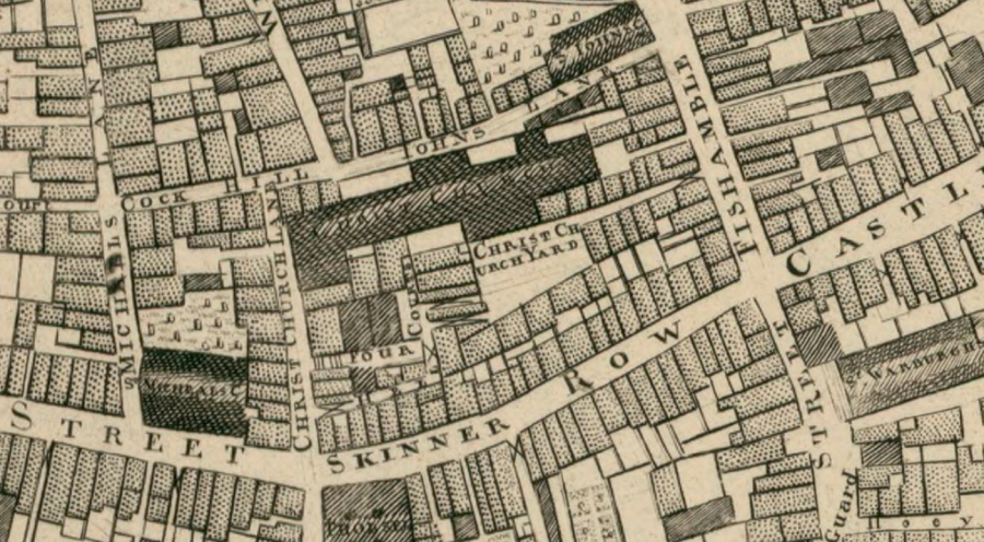
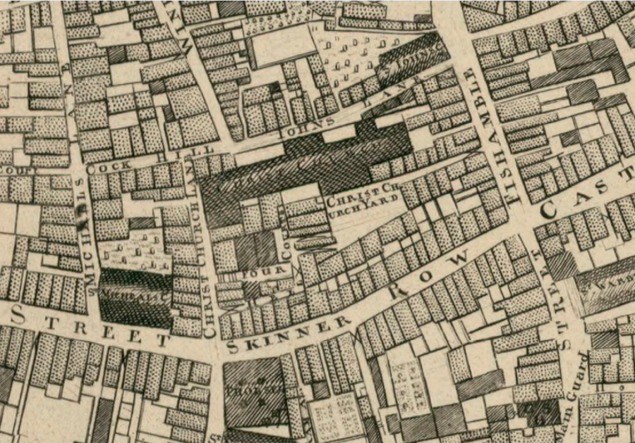
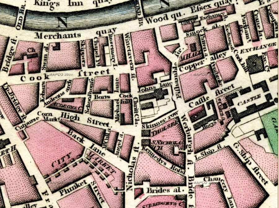
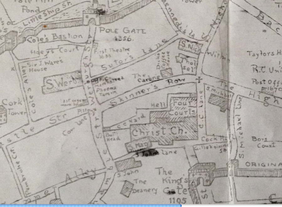
At the bottom-right of this section of Rocque’s map, above we can just about make out the word “Hoey” That’s part of Hoey’s Court, in other words the birthplace of Jonathan Swift, hard by the walls of Dublin castle. The castle which is just off the map here, just off to the right/the east. Above Hoey’s Court, St Werburgh’s is clearly visible and above it Castle Street. Here’s a slightly different, overlapping section of Rocque’s map to make the point better.
Whichever section you look at, the first, most striking thing you notice is that Lord Edward St doesn’t exist. Not just the name. (Edward FitzGerald wasn’t even born in 1756) The street itself doesn’t exist in 1756. In the absence of Lord Edward St therefore, Castle Street- which today we think of as a small almost backstreet- was the main artery through the old city. You’ll also notice City Hall (formerly the Royal Exchange) is not there either. It was only built in the 1770s. (By architect Thomas Ivory). Parliament Street on the other hand is there. But only by the skin of its teeth! It was laid out (meaning planned, bought up, and divided into plots which were sold or leased, (along with some very stringent building conditions)), at the exact time this map was made. So it just made it into the map.
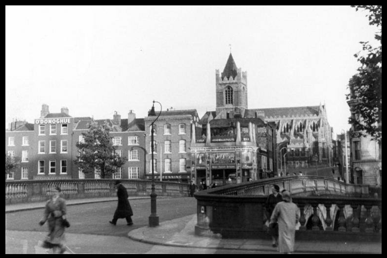
Going East to West, Castle Street then links to Skinner Row, (see above or below) In front of the cathedral you’ll see it, Skinner Row. This was much narrower than the current freeway-style monstrosity that guides thousands of cars very day straight past a 1000-year cathedral, just yards from its ancient walls. Yes it’s true the cathedral was heavily restored in the Victorian era. But much of the fabric is still medieval. And anyway so is the institution as a whole. So no valid excuses for motorways in the middle of a medieval city! It’s a bloody disgrace, to be honest with you. Utter philistine nonsense.

The space in front of the Cathedral was much narrower in Rocque’s time Obviously the roads are vastly bigger now. And the Cathedral 1756 is, as you see, surrounded, absolutely smothered, by a plethora of houses! Today the cathedral is clearly visible to the road/motorway. But then? Look at them on the map below. These thick rows of dwellings surround and screen the cathedral, surround it, entirely so on its North and East sides.
Even behind the rows of houses, there is another layer of buildings crowding the cathedral, including the Four Courts. Sometimes hard to believe today, but this is where the law courts met. prior to their move just across the river to the Cooley/ Gandon building. (Moving only in at the turn of the 19th century.) By the way, the King’s Inns was in this same area too, until they also moved, way up to Henrietta Street, just a bit later.
But I’d like to draw your attention back to two, much more general characteristics of the old city. First the narrowness of the streets, which in modern terms are more lane-ways really. And second, to emphasise again the sheer clutter of houses. Both characteristics tell us a lot about the extraordinary density of the medieval city. In my view this is the single-most important thing to grasp if you want to picture medieval space. But it’s not always easy. As a mental image to help me, I use the words I once heard an Italian academic use to describe the difference in these terms: that buildings from the early modern period were placed in space, whereas space in medieval and pre-modern cities was more like tiny channels scrapped out of mass. Does that make sense? Another way I try to explain it on tours is to picture a block of that green “oasis’ stuff people used to put artificial flowers in. Then imagine scratching and scrapping channels through that solid green block. Those little groves you make in the block in your minds eye are your medieval streets, your tiny courtyards and alleyways. Some, like Crampton’s Court in Temple Bar (which still survives) or Hoey’s Court (which doesn’t) were small but manageable. Others would have been tiny; scarcely bigger than a light shaft or a lift shaft today. Imagine: nearly everything else as just solid mass: of house, of church, guildhall, great leaning piles of damp brick and timber. Timber? Remember Dublin prior to the Georgian era was full of Dutch Billys, and prior to that, Elizabethan cage houses.
Dates? Well, for our Italian academic “Pre-Modern” means “up to the Renaissance”. Give me dates, damn it says you! Well again it depends where you are. To our sophisticated Italian professor, the city-changes occurs as early as the 1400s on. Although naturally, not everywhere, nor all at once. Wealthy highly developed cities like Florence are far ahead of others. The “Renaissance in Dublin” on the other hand never quite arrives. Or at least not until around the 1660s earliest, the Duke of Ormonde’s return being a favoured date, (triggering the building of the Royal Hospital Kilmanham and the rebuilding of Dublin Castle, in the classical style). So “Medieval Mass” (if we may call it that) was a state of affairs which in Dublin’s case prevails well into the 1700s. By the way, for the sake of clarity, in case I’ve given the impression that everything was ancient or (worse) rotting and falling down by 1756, or even 1956, I don’t mean all these houses on our map were all still medieval in date, at either date. I don’t, and they weren’t. Obviously, dwelling were fixed, repaired, rebuilt and replaced all the time. That’s the nature of cities. That’s the nature of things. It’s the Street Plan, and that Density which is medieval. Look again the way houses crowd right up to the edge of the cathedral and other large public buildings. Of course there was lots of old historic building fabric too. All mixed up from the whole long range of different eras, including the piles of Viking houses, buried just a few yards underfoot. Meanwhile because the new streets of the WSC mostly happened in their new centre to the East, much of this historic building fabric in the old centre actually survived right up until the 1960s, as we shall see.
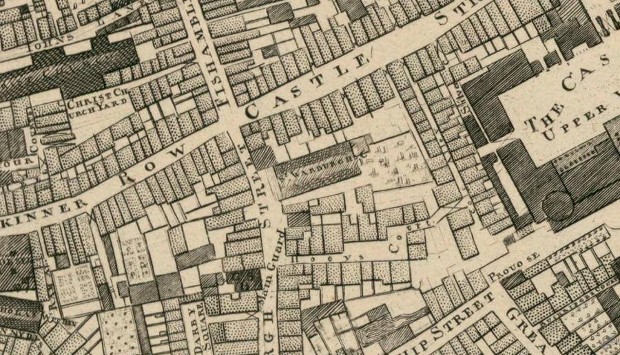
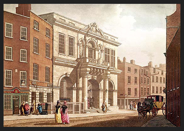
Look at Rocque again. Across the road from Christ Church at the junction of Skinner Row and Nicholas Street stood the Tholsel, once the equivalent of City Hall and the head quarters of Dublin’s Guild of Merchants, rolled into one. Probably the single-most important secular building in Dublin for hundreds of years. Here’s the most famous, and much-used image of it as painted by James Malton.
Right beside the Tholsel, going South down Nicholas St, stood the ancient church of Saint Nicholas Within. (There’s still a stump of it there, albeit slightly moved back from the road) Just beside that (beside Nicholas Within I mean) the old medieval city wall stood, right up to the 1680/90s. Or more specifically, St Nicholas’ Gate stood, one of the six main gates of old Dublin.
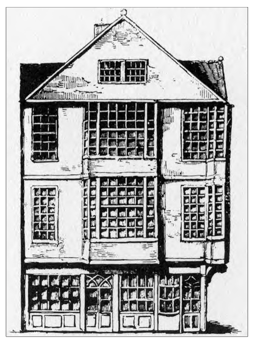
On the other side of the Tholsel, if you crossed the junction with Werburghs and went down Castle St back towards the Castle, was Carbury House. This was the last Elizabethan cage house to survive in Dublin. The cage house you’ll recall is the building-type that pre-dates the Dutch Billy, (which predates the Georgian, and so on) Carbury House, which was once the town house of the earls of Kildare, then later used by wealthy merchants and professionals, stood on Castle St. It was only demolished in 1812.
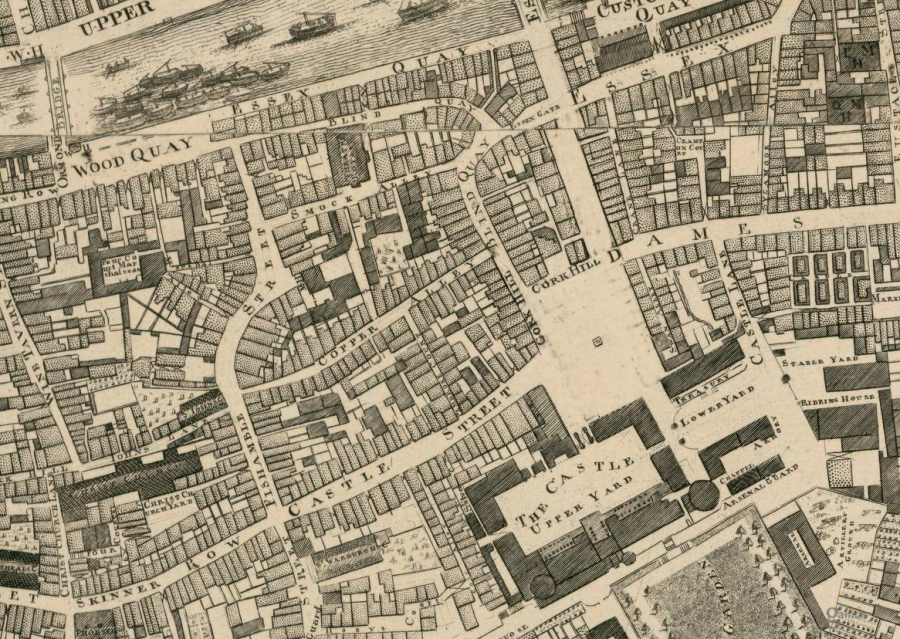
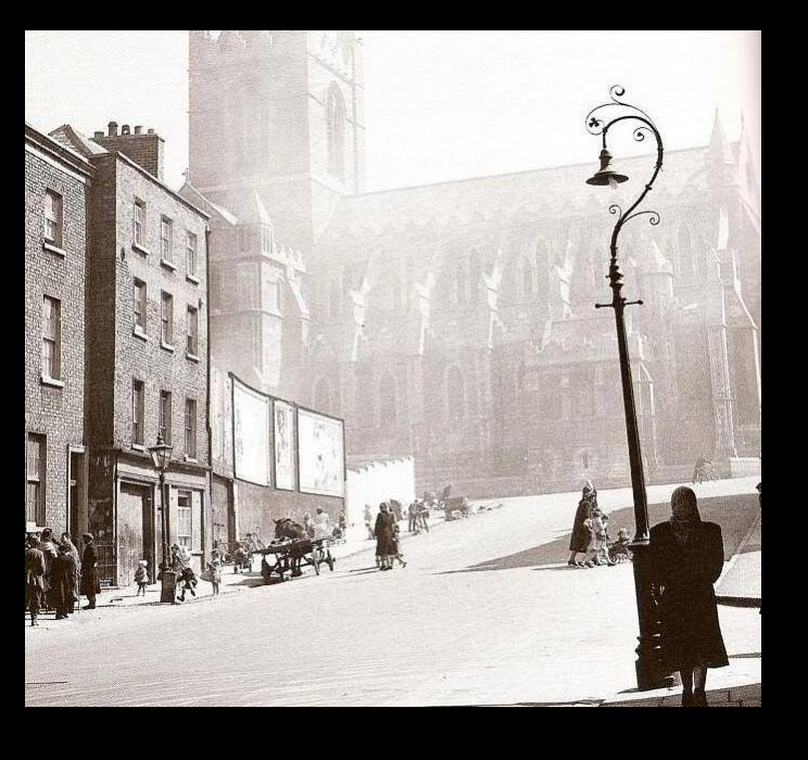
We’ve looked at Castle St and Skinner Row. Let’s now go the other way, back across Skinner Row, to Christ Church and its immediate area. We’ll take a god hard look at the area we now call Wine Tavern St. Here’s an amazing photo of the NW corner of Christ Church, and Wine Tavern Street. (All photos reproduced courtesy of Tóirdhealach O’Braoín. Please do not use without written permission)
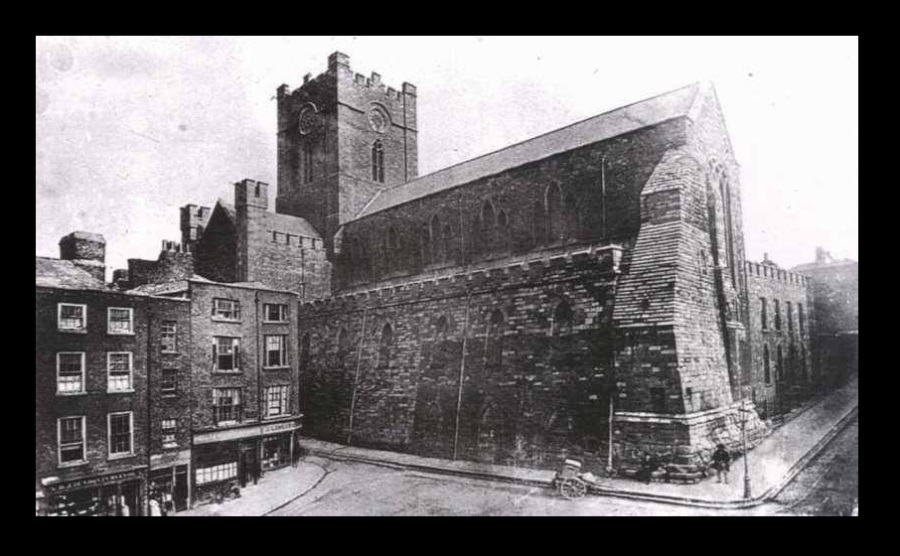
I often make mistakes on my blog, including some really, really sillly and embarrassing ones. A consequence of too much rash enthusiasm perhaps! So I’m very open to correction here but this appears to be a really early photograph, showing Christ Church before its 1878 Restoration, no? Obviously the cathedral changed a lot during that huge, extensive restoration, (almost a rebuilding really) But so too has the entire layout of roads, churches and houses in this whole immediate area. For example, in the photo, the stretch of road to the right (west) of the great hulking cathedral wall should be here called, properly speaking, Christ Church Lane, not Wine Tavern Street as we all say today. In our snapshot of time, anchored to our main 1756 map, Wine Tavern Street only started further down the hill, then ran down to the river. Christ Church Lane was (is) the right name for the small lane which connects Skinner Row/High Street to Cock Hill. This is a detail of a map by Leonard Strangeways, made in the 1900s to work out the route and position of the walls and major buildings. Confusingly North is down and South is up. It also does nothing to illuminate the density of old Dublin. But it does show clearly old Christ Church lane and old Wine Tavern Street, which here is only the shorter road running from Cock Hill (Cock, not Cork) down through the Kings Gate, down to Wood Quay.
You may wish to look at both maps to follow all this stuff!
The top of Ch Ch lane is where it meets Skinner Row. Down the lower end of Christ Church Lane is the intersection where (more or less) Cock Hill becomes John’s Lane. At this same point is a T-Junction, they meet the old, original Wine Tavern Street, coming up from the river, and once crowded with taverns and bawdy houses. With me so far? Phew!
Quick digression on the subject of “taverns and bawdy houses”. Did you know the lovely crypts of Christ Church used to be full of them? Oh yes. The cathedral used to rent out the space to tobacconists, taverns and who knows what. It was quite the den of inequity in its day, under the cathedral. Dublin was not unique in this respect. Over in central-east London the Bishop of Winchester used to own lot of city land. His main tenants were mostly involved in prostitution. In fact, he benefited so much from the trade, (quite knowingly) that ladies working in that professions were called “Winchesters Geese”. For the record, I’m not insinuating anything. Still less accusing any past Dean or chapter of Christ Church of anything untoward!
Getting back to the more serious matter of our changing, oft-abused city, it goes without saying the maze of street junctions and lane ways just outlined, and visible on map above, has completely gone. Christ Church lane has gone. St John’s church is gone. Michael’s Church, replaced by the Synod House in the 1870s Restoration, gone. At least in that case Michael’s was replaced by something beautiful. Not so elsewhere.
Looking at this map, things are so different today it actually gets confusing. One thing to clarify one more time is that St Michael’s itself was rebuilt during the cathedral’s Gothic Revival-style restoration. It became the Synod Hall and this was linked across the road back over to the cathedral via that lovely Venetian Gothic-style “Bridge of Sighs” This rebuilt (Synod) building, occupying the same footprint as old St Michael’s, is now right up against the modern road.
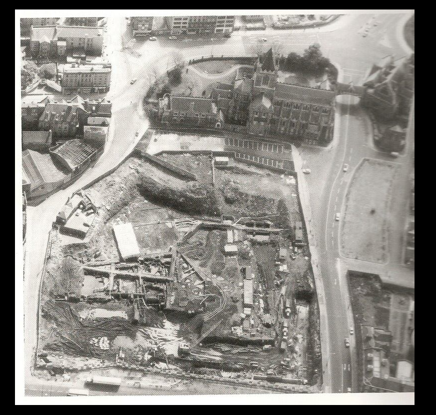
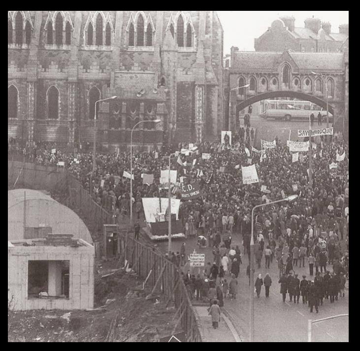
The much extended Wine Tavern Street, despite bearing the same name, is basically gone. It was of course destroyed entirely on its east side from John’s Lane downward. The buildings on the right (left here) have nearly all been replaced and infilled. On the other, east side of the road? Even worse. As all Dubliners know, from John’s Lane downward, the entire area was savagely torn down in the 1980s to make way for for Dublin Corporations headquarters. Das Bunkers. Yuch.
Here’s an amazing aerial picture showing the sheer extent of that destruction. It shows the excavations of the archaeologists, trying to recover (on a time limit) what they could of Viking City under the later medieval and early modern houses. But what the picture also really illustrates to me very powerfully, is how the entire former maze of old streets and houses was just torn down and consigned, brutally, into the dustbin of history. Dublin Corporation, as it was then, had no right in my view, to tear down an entire section of our ancient capital. Disgusting and very short sighted abuse of power.
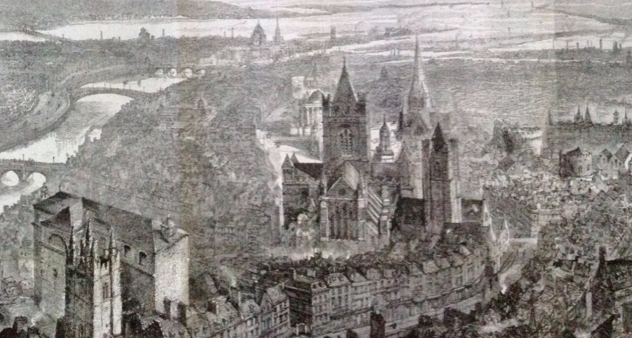
Here’s an another “aerial picture” the famous, superb engraving that appeared in 1890 as a supplement to “The Graphic” (newspaper) drawn by W.H Brewer (aptly enough) A Bird’s Eye View of Dublin. The viewpoint is purely imaginary, the spaces and positions of buildings all artfully distorted, to allow a maximum of picturesque sights. Yet I love this picture. In the area beside and behind Christ Church, it also shows, (magically, yet now poignantly) the sheer extent of what would be lost forever. It also conveys some sense of the jumble of houses and ancillary churches around Christ Church, and the general atmospheric of historic Dublin. (Both Saint Audoens (C.o.I and RC) are in foreground-left, then old St Michael’s; old Christ Church are further back, both in middle ground and centre-frame. With I think that’s old Saint John’s visible behind Christ Church?
Here’s just one of the hundreds of buildings lost forever in those demolitions. This incredible spot, Timoney’s Pub, also known as “the Irish House” stood at the foot of Wine Tavern Street, turning the corner onto Wood Quay to face the river.
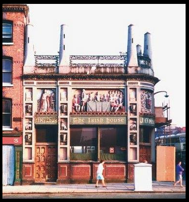
It featured an extraordinary array of exterior sculpted decoration, on patriotic themes, including a statue of Daniel O’Connell (holding his Repeal Act)
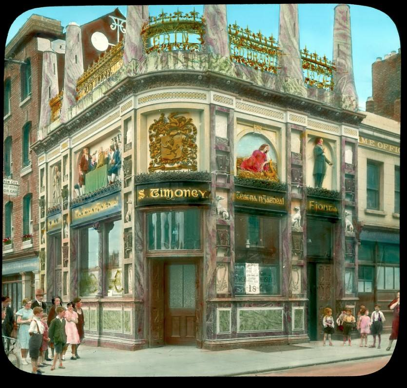
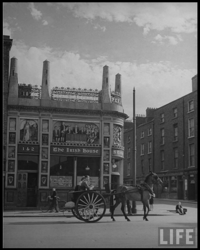
Photos reproduced courtesy of Tóirdhealach O’Braoín.
This pub was once one of the “sights” of Dublin. It featured for example in Life magazine. Neither that celebrity, nor the protest of tens of thousands of outraged Dubliners during the famous Wood Quay protests- were enough to save the district from annihilation.
Back up on higher ground, above the cathedral, so to speak, Lord Edward St was also driven through, at an angle snaking up the hill (lopping off a corner of Fishamble St on the way) while Skinner Row was massively widened (loosing its name and identity in the process) as that new Lord Edward joined High Street. Then in the 1960s High Street was further widened to make a motorway. Directly in front of the cathedral. Yuch. And after this they then knocked down the Irish House and its surrounding district, in the 1980s. You couldn’t make it up.
Admittedly, as we said at the very top of this article, over to the east of the Dublin Castle, the old 1600s-early 1700s street plan also changed radically as from 1757 the Wide Streets Commission used their vast powers (including compulsory purchase orders) to both destroy, and to create huge and, well very Wide streets, as they effectively re-made the city. In doing so, they also dragged its whole centre of gravity East, toward the College, the Parliament, and that new Grafton Street-O’Connell Street axis. Meanwhile the so-called West, in reality the old centre, became ever more neglected, a victim of changing fashions, the pattern of development just discussed, and steep economic decline (largely due to some really pernicious English trade laws). By and large therefore, no Georgian terraces were built in the area we now call the Liberties. As a direct consequence of that semi-benign neglect, old Dutch Billy townhouses and other ancient fabric, survived much longer in the west than east. That’s why we have a lovely, intact, medieval quarter there to this very day. Right? No of course we don’t. Independent Ireland, and the general and, in fairness international 1960s obsession with the motorcar, saw to all that. Motor cars meant progress. Out with the old, the lame and the tired. In with the shiny and new. But a nation of motor car owners need wide roads. We are lucky we still have the canals. They were nearly infilled and tarmac-ed over too.
So it was that various Governments (National and municipal ) in the post-Independence era achieved what Ascendancy Georgians failed to- the destruction of the Liberties. This was now enthusiastically completed, some 200 years after the WSC was formed.
Make no mistake, English Trade laws did huge damage, socially and economically, and pure human suffering, to west-central Dublin. On a par with the mindless (they would say high minded) destruction of religious art 200 years previously. But most of the actual tearing down of old buildings in the Liberties, admittedly sometimes in very bad condition- was done post Independence. Ascendancy Georgians had plenty of faults, monopolising power and wealth like spoilt, bigoted children. But they did at least have one, partially redeeming feature, a sense of pride in the city and some notion of taste. They destroyed most of pre-modern Dublin to the east of Dublin castle. But they at least managed to replace it with something elegant, cohesive and harmonious. Would to God we could say the same of the Governments of the Free state, Irish Republic and the municipal Government of Dublin Corporation/ City Council.
Many thanks for reading this rant, dirge, my lament! Please feel free to share and/or leave a comment. It’s always great to hear from readers and fellow history lovers. I can’t promise to answer queries though. Some of the material is complex, either spatially or even on occasion historically. Some of it is contentious. I find it takes forever to answer seemingly innocent and simple questions in a clear and satisfactory way (Clear and satisfactory to me anyhow). You can however come on a walk sometime, and ask all the questions you’d like. I’ll certainly try do my best to answer them on a walk. There are 2 different types of walks by the way, private ones, which you commission on a date you chose for your own group. Price depends on route and size of group, so we ask you to specify that when you get in touch. Separately, there’s another type of walk, our public walks which are obviously open to everyone. These tend to be around the €15 mark and very sociable and good fun, due to our horribly knowledgeable Dublin guests! 🙂 The best way, almost the only way really to hear when public walks go ahead is via our free monthly newsletter.
In our next post we’ll visit St Audoen’s and Cook St, then later the old Corn House and the notorious “Black Dog” debtors prison. We’ll also look at the vanished Dublin institution that was… the Watch House. I hope you’ll join us then.
As a final treat, here’s a nice film of old Dublin, including the Irish House pub, on this collage of old film footage. If you look carefully you’ll see the amazing external decor of the Irish House, including that statue of Dan O’Connell and Repeal Act. The movies were shot by a Mr Leslie Crowe in the 50’s, 60’s and 70’s. He was a Dublin firefighter who spent his spare time filming the old cuty. What an incredible gift, and record, he left us. Don’t forget to hit that newsletter link if you’d like to join a walk sometime. The subscribe link opens in separate window, so don’t worry, you won’t loose this page or the movie link 🙂 Enjoy!

Right, that’s it. One of your walking tours are going on the ‘Wish List’! See you sometime xx Brilliant knowledge and insight. So glad to have found you
LikeLike
Thanks for your kind and gracious comment Hilda. Delighted somebody managed to actually wade their way through this Marathon post! Even more pleased you enjoyed it. Makes it all worthwhile when people enjoy/comment. Yes please do come on a walk sometime. That mailing list is the way to go. Would love to have you. Jolly good fun as well. It’s not all misery and outrage on the walks. i promise!
LikeLiked by 1 person
Hi Arran,
Just discovered this wonderful site ” Tour Old Dublin ” which brought back great memories as I was Born in 1943 on St. Michael’s Hill now Wine Tavern Street and lived and grew up there until we were moved in 1955. The “Hill” Address ran from Cook Streeet up to Christ Church on the right hand side.
Thanks again for the Memories and Photos especially the one with the kids swinging on the Lamp Post as it would have to be my sisters or cousins as they spent a lot of time on that very same spot. We lived facing it.
All the best,
Parrick.
LikeLike
Hi Patrick, I’m absolutely delighted that you found this, and I’m even more pleased it brought back such great memories. And honoured! Thank you very much for taking the time to respond. Makes all the difference. -Arran.
LikeLike
A thoroughly enjoyable read… Many thanks 🙂
LikeLike
The Pleasure is all mine John. Thanks for reading, and for your kind support.
LikeLike
Really enjoyed that. I’m not a dubliner but work in this area and have always wondered about the original layout around Christchurch on my lunchtime rambles. Very insightful article. Would have loved to see some modern street plans overlay end on the old maps to help find bearings and illustrate differences.
LikeLike
Thanks you very much Peter. Yes, it’s a good suggestion that, about having a modern map to compare. I thought about that, and then got distracted by some other aspect of the piece! I’m also a little concerned that it will / could possibly – improbable as this may sound- muddy rather than clarify some of the spacial understandings. The transformation / devastation really has been that complete. But i shall look into it again. May even modify this, to include modern map. Anyway, thanks again Peter.
-Arran.
LikeLike
Must dig out a 1930s or so aerial view of this area. Astonishing network of streets and buildings. Was posted on Archiseek a few years back. Will see if it’s still there. Great rant Aaron 😉
LikeLike
Sounds great Stephen, please let me know if you find that. Naturally I’d be very curious to see it. Delighted you enjoyed the above too. Well done for wading through it! Thanks for the support as always
– Arran.
LikeLike
This is a great post Aaron – I did my PhD on medieval Dublin and lived in the Liberties for a few years so this area has a special place in my heart! Looking at the modern street scape it can be difficult to imagine how much it has changed – and, as you point out, the changes are recent. And your love of Rocque is similar to mine of Speed!!
LikeLike
Thank you very much Grace. Very nice to get such nice feedback, and from a proper medievalist-historian too, an expert in the field. I know you of course, as a fellow member of John Gibeny’s (crack) team of Culture Night guides.
I don’t blame you for loving Speed’s map. Am totally in thrall to Rocque through. What fascinates me is the way it is right on the cusp between Medieval and the early Modern periods, with the world just about to change forever. Must have spent hundreds of hours looking at it (Not as a figure of speech, literally) Yet you still feel like you’ve barely scratched the surface. Almost no limit to what one can find there. Endless revelations. Endless food for thought.
Have you come across Leonard Strangeway’s little “Walls of Dublin” map? Perhaps it’s semi-obsolete. Maybe it’s been replaced by much better and more modern scholarship, I don’t know. But it was my first entry into, introduction to, medieval Dublin, so I love it.
Many thanks anyhow for your kind comments. Very much appreciated.
LikeLike
Just a thought Arran about your discussion with Peter above – I’m a big fan of the Irish Historic Towns Atlas fascicles – Dublin Parts 1 and 2 – Part 1 was a constant companion throughout my PhD and one of the maps has an overlay of the medieval city (840-1540) onto the modern (Ordinance Survey 1939) and is great for understanding the shifting street patterns over the centuries.
Do you know John Montague? He did his PhD on Rocque but I have a lovely publication he did with Colm Lennon in 2010, ‘John Rocque’s Dublin: a guide to the Georgian city’ – a must for any Rocque fan!
G.
LikeLike
Hi Grace, yes I know John Montague, a terrific scholar, and thoroughly nice chap. Last saw him at a super talk he gave, at the AAI, last autumn, on a separate topic (not Rocque) But yes, I’m familiar with his Rocque book with Colm Lennon (another first class scholar, I’ve read lost of his work, constantly brilliant) For some daft reason I don’t actually possess a copy of their Rocque book, even though often read sections of it, (in libraries, etc) I shall certainly get a my own copy at some stage! It’s excellent. The one thing I would say is that they were confined by space to just cover a few dozen areas and topics, and these, despite their genuine and huge erudition, not in great depth, again purely by space reasons. The amazing thing about Rocque is the sheer volume of visual and historical information in that map. Indeed there’s so much, you could spend a lifetime, (and publish a Borges galaxy of books!) and still not exhaust the endless lines of inquiry. That’s what i love about it! 🙂 It’s a good reminder nonetheless. Will get a copy of John and Colm’s book. If only to make sure (for one thing)- that I’m not duplicating their work!
As regards the map overlay suggestion that Peter made, I’m looking into this. Yes, i know that (over-laid) map you mean. It is one of the images within the Historic Towns Atlas folders, (the Dublin one obviously) but was previously published and issued separately, in various versions. I have one here. If only I can lay my hands on it! When I do, shall certainly frame the Christ Church section, and include it up above. Again, it’s a very good idea. Thank you very much Grace. You’re very kind. Appreciate the ideas and support. -Arran.
LikeLike
I’d forgotten about the previous publications – it’s a little green one – I used that and the Dublin Part 1 version so much that they were held together with sellotape by the time I was done – I’ve a few map-related ideas for research that I’d love to do – just need someone to fund me!! And teach me advanced GIS! Have you seen the DCC GIS project that was launched a while ago – I have a link somewhere if you haven’t – it highlights archaeological sites on map of the city – a great way to see what lies beneath.
As for Rocque – the map is really a work of art – I love little details like the trees and how detailed the ships along the quays are – all unnecessary for the cartographic purpose, but just some of the things that make it so valuable and fascinating. You’re right about the book, I suppose it’s almost a coffee-table book in ways because it’s so visually appealing, but it’s lovely to dip in and out of it whenever you want to read up on a particular area, and the fact that both authors are so erudite it’s great to be able to rely on the content!
Still have a special place in my heart for Speed though – as inaccurate and all as it is!
LikeLike
We are on the same page here, I’m absolutely Dying to do some far more ambitious map related work. My goodness, have you seen the animated map / map-film / moving time line that the historians in London did? Absolutely stunning, and such a powerful learning & educational tool as well. (*Let me know tomorrow or over weekend if you don’t have / know / see it online, and I’ll find it again, & send you the link. ) Talk about “bringing history to life”, in that overused phrase. But it really does. As I say, am dying to do something similar, make an animated map / map-film / moving time line showing the development of Dublin from pre-history to present. Although as a humble art historian (ie: Not a trained academic historian, nor an archaeologist, and no PhD to my name) seeking funding will be an interesting experience! You never know though. Just need to find me a millionaire (no kidding) , and also learn some serious software programme skills. I will though. 🙂 Everything is possible, with enough determination.
LikeLike
Have you ever seen the dvd ‘Medieval Dublin: from Viking to Tudors’ (second edition available aswell) – produced @ 6 years ago now – in collaboration between DCC, Dublinia and a whole host of others. It was done with primary schools in particular in mind but even for us grown up historians I think it is beneficial, and it was really really well produced. If you can send me a link to the London one – love to see it.
LikeLike
Yes, I know and have those DVDs, (there are two of them in the set/ the case, as i remember) They are on shelf somewhere behind me, amid the general chaos! They’re an excellent project, with nice (CAD/CGI-type) visualizations of the old city. Another, more spatial, type approach would be something like that animated map of London I was telling you about. Here is the link to that, see what you think of it. It’s one of my ambitions to be involved in a similar project here. Would love to see something like this made available for Dublin. https://www.youtube.com/watch?v=NB5Oz9b84jM
LikeLike
Hi Arran
My great grandfather had a business opposite Christchurch from late 19th century, John Arigho and Sons, Christchurch Place. They did church statuary, printing for the Catholic Church, carpentry work and similar and were quite well known in Dublin. They became very prosperous by the early 20th century. I think there is a Jury’s Hotel on the site now. They used mews in one of the back streets for horses. Do you have a picture of it?
LikeLike
Hi Mary, thank you for this fascinating information about your great grandfather’s business. It’s exactly the sort of information I love getting, (and am always hoping to get!)
No I don’t have any photos of the mews or its horses. I was hoping you could send me some to be honest! or of any part of the premises, (the front of the shop, anything. Even a photograph of an old print or engraving. If there isn’t a photo or image of the shop itself, old advertisements are interesting too.
Do please let me know if you have, or come across anything like that. If you tell me here I could send you my email, (only if you wished to send me an image) I could include an image in the piece above, or the next piece, which concerns the same area.
Anyway, even if yo don’t have anything, many thanks for the message. Its fantastic to start filling out the mental picture with information just like that. Arran.
PS: Are you on Facebook? If so, perhaps look up and find the account of the man I mention in the piece above who has all the albums of photos on Facebook. Tóirdhealach O’Braoín He might have one of the horses and carts etc at the mews. It’s worth just looking at the pictures anyway. They are great!
Best regards again. -Arran.
LikeLike
Hello
No pictures at all – cousins may have something.
John and Louis Arigho were Swiss Italian and came from a little town near Lake Como.
They were at Castle St from 1881 to 1916, then Christchurch Place to 1931, according to John Arigho and Sons, Mapping the Practice and Profession of Sculpture in Britain and Ireland 1851-1951, University of Glasgow History of Art and HATII, online database 2011 http://sculpture.gla.ac.uk/view/organization.php?id=msib3_1208530449, accessed 12 Feb 2016]
Active: 1881 –
Function: Carvers, gilders and looking-glass manufacturers, statuary manufacturers
History or description: This firm also was involved in publishing. There are some references to their publications in the catalogues of the National Library of Ireland and British Library, for example ‘The Genuine Irish Old Moore’s Almanac, etc.’, J. Arigho and Sons, Dublin, 1928. They r published prayer books.
Locations
View all on map
Ran a business at 12 Castle Street Dublin | View on map
1881 – 1891
‘Carvers, Gilders and Looking-Glass Manufacturers’; ‘Statuary Manufacturers’.
Ran a business at 17 & 18 Christchurch Place Dublin | View on map
1916 – 1931
‘Carvers and Gilders’; ‘Statuary Manufacturers’.
A newspaper ad from 1917: Church Furniture Manufacturers
Estimates and Designs Submitted.
John Arigho and Sons, Ltd.,
Christchurch Place, Dublin.
LikeLiked by 1 person
That’s all extremely interesting Mary. It’s great to get a glimpse into the business life of the area prior to the awful broadening and general re-development. I appreciate that extra information. Thank you very much again.
-Arran.
LikeLike
Hi Arran, a fantastic post, such a great read. Have you seen the new (new to me anyway!) online maps that SDCC have put online? One or two I hadn’t seen before, and no crazy watermarking on them. http://sdublincoco.maps.arcgis.com/apps/webappviewer/index.html?id=e0c5595b033341dea7661e248d2e9ee9//
LikeLike
Hi Rose Anne, no I had not in fact seen this amazing resource. I’m very grateful to you. The interface is super, wonderful the way one can jump so quickly between maps (and of course different eras. What a great heads-up. Thank you!
LikeLike
I thought you would enjoy it, I am sure you lost your evening to it after finding the link! It is so easy to spend hours on these maps. Best wishes
LikeLiked by 1 person
Was browsing the site and came across the discussion above regarding the Vikings to Tudors; Medieval DVD. This is, as Grace said, now online so I thought I’d include the link here. Thanks for a great site…
http://dublinia.ie/online-learning/
LikeLike
Hi Sheilia Glad you came across this article, and I’m absolutely delighted you’ve included the link to the Viking to Tudors online resource, Thanks for doing that. With all the maps and videos and everything it is an absolutely brilliant resource. I have and use both the DVDs and the Phone Ap myself, both of which I find super, but this is even better perhaps as its so interactive and searchable and intuitive. Great initiative, great resource. I’m delighted to see that and if I get a chance some time soon I’ll certainly put a mention up on our Dublin Decoded Facebook page etc.
Thanks again- Arran.
LikeLike
Delighted to have this link. I’m teaching a course on medieval sources to first years this term and one element is using what remains of medieval buildings (the Castle, Christ Church etc) as a clue to their past – I’ll be showing this in class as it’s a perfect demonstration of how the city expanded around many of these buildings. Thanks Sheila! Grace.
LikeLiked by 1 person
Thanks very much for your amazing description of medieval Dublin. I particularly appreciate the material on the Irish house. Just one question: Is the photo of the NW corner of Christ Church and Wine Tavern Street not of St Auoden’s with the city wall in front of it? I was trying to reconcile the wall with the large drop behind Christchurch but St Auoden’s seems more likely. There was a lot of changes around St Auoden’s with the widened streets and the place where there is a park there was entirely different. There was a Winstanley Hall there I think where the road is now….
LikeLiked by 1 person
Hello Joe, I’m delighted you enjoyed the piece and thank you very much for your kind comments on it. As regards the photograph of the large religious building, no it is not St Audoen’s, although I can entirely understand why you think it might be. It looks a bit like it alright, because of the very large drop behind the building and because of the sheers mass of the back of the church etc, and most of all, because of the parts that appears to be city wall. But in fact, that’s just the (heavily-buttressed) side of the cathedral itself, of Christchurch (ChCh) And that’s part of the difference by the way, its the side of the cathedral, whereas at St Audoen’s its the back of that great church which projects out over the drop below.
In addition, if you look at the ChCh tower, you’ll see that it (unlike the rest of the church, which was of course heavily restored/ rebuilt) the tower at Christchurch (ChCh) and it has remained substantially the same. It is Medieval in origin and remains medieval in style, even post-restoration. So that is a useful visual clue. At St Audoen’s (St Audoen’s RC, the relevant one here) the style of architecture is quite difference, although admittedly, that’s less apparent from the back. But at St Audoen’s it is the back you see, looming over the walls. What you are looking here is the side of ChCh.
In truth and in fairness, it is difficult to read these mages, because the streets both above, below and to the the side of Ch CH have been widened so drastically, and the whole areas around it re-landscaped so so much.
Remember that Winetavern St did not reach up to Skinner Lane/High St, the way it does today. Instead there was a smaller street called Christchurch Lane that went half way down the hill, then met at the junction of Cock Hill and St Johns Lane. Only from that (lower) point did Winetavern St start going down the hill to the river. That is what you are looking at, in the old photo, that meeting of streets, at exactly that point. Just before the cathedral was rebuilt, and before Winetavern St was both lengthened, (up to the junction of to Skinner Lane/High St) and also before it was dramatically widened as well.
Hope that is all of use, helping you to visualize the medieval and early-modern layout.
Thanks very much for reading.
and my very best wishes
-Arran Henderson.
LikeLike
Thank you for your wonderful research on medieval Dublin. I am particularly interested in what would have been key locations/buildings in 1641. I assume Lord Cork used Cork Tower as a local residence, and Borlase was in Chichester House on what is now the College Green. Do you know if Ormond or Coote (Sr) had an “in town” abode or where the affluent politicians would probably have stayed? I found the transcript of Owen O’Conelly and he mentions Col. Mac Mahon was lodging near the “Boot” in Oxmantown. Would that be an establishment or a location? Also he mentions they went to Mac Guiire’s lodging at a Mr. Nevil’s, a “chirugeion” on Castle street (near the pillory), but not finding Mac Guire there, they went on to “The Lion” on Winetavern Street and got soused. MacGuire finally gets caught in a “cock-loft” in an “obscure house far from his lodgings.” I wonder if you have any insight where that might have been? Any information you can share about Dublin in 1641 would be greatly appreciated.
Regards,
Karen Rochford Tinsley
LikeLiked by 1 person
Hi Karen,
Richard Boyle, earl of Cork, certainly used his townhouse, Cork House, on Cork Hill. Cork Tower was part of Dublin Castle and I believe he paid for its repair and/or possible rebuilding at one point, and may have had the use of it (possibly for storage/ trade, I don’t know, but he had huge business interests all over the south of Ireland, so it could have been for that) bHe also had his coat of arms on the exterior of it (Cork Tower) at one point. But he lived as i understand it, in Cork House.
As for the rest of your points, the “Boot” in Oxmantown, sounds like an establishment to me, like an inn or a tavern. As reagrds wealthy pliticians etc, they seemed to stay n all sorts of places. But I don’t have any specific information on those issue. But have you come across Gilbert’s History of Dublin? There is a 3-volume set, it’s fabulous. It may be out of print, I don’t know, but even if it is, you would be able to access it if you get a reader’s ticket at one of the good University Libraries, or possibly the Dublin City Archive at Pearse St. Seek out Gilbert, if you can? He is an absolute mine of information, highly recommended!
The only other thing that occurs to me is, have you sought out or found the Transcript of the 1641 Rebellion testimonies? (Recorded around 1641, 1642, during or just after the Ulster Uprising) Many of the survivor fled to Dublin. Their testimonies were transcribed, then republished by historians just a few years ago, with a commentary.
It may not shed direct light on your issues. But if you are researching the period it is right in your time frame, and may provide other insights. So that might be worth Googling or finding as well?
Good luck with your work. Hope that is of some use.
– Arran.
LikeLike
Thank you for your suggestions. I just downloaded all three volumes of the Gilbert book. As for the Depositions, yes, I have explored those. They make for a fascinating read (even knowing some of them have been “embellished” a tad.) I missed visiting the old part of Dublin when I made my first trip in 2015. I went to Cork to visit the church where my 4th great grandparents were married in 1776. Yes, VERY cool!. I will delve into Gilbert’s volumes next and see what I can find. Is your expertise limited to Dublin? Or are you an historian of other locations in Ireland? I hope to visit again to do more “personal” research (my first attempt at a novel) and will definitely book one of your tours.
LikeLiked by 1 person
Hi Karen (and Arran) – hope you don’t mind me jumping in here – just a couple of suggestions if you are looking for sources to research late medieval/early modern Dublin.
The bibliography on the Friends of Medieval Dublin website would be a great place to start: http://fmd.ie/bibliography-2/
To learn about the evolution of Dublin’s urban landscape, the Irish Historic Towns Atlas is invaluable.
It is available online here (https://www.ria.ie/irish-historic-towns-atlas-online) but inexpensive to buy and very well worth having a physical copy for research.
LikeLiked by 1 person
Hi Grace, I’m delighted you intervened, many thanks. Karen, these are all excellent suggestions by Grace (Dr. Grace O’Keefe, medievalist) I heartily endorse!
LikeLike
Hi Aaran, I understand and thanks for the very detailed explanation. I’ll have to really look at it again next time I am there. I think then that they must have really changed the elevation of the land behind Christchurch to bring it up to where it is now, as the slope, although steep, is not sheer as it looks there. That’s what is confused me.
LikeLiked by 1 person
Grace,
I am sorry my thank you post didn’t make it here earlier! I just finished taking notes of the Gilbert volumes and will now move on to your suggestions. Thank you for the links!
Warm regards,
Karen
LikeLiked by 1 person
Hello Arran,
This was very informative for me. My great great great grandfather was named Daniel Kelly who was born in Fermanagh but as some point came to Dublin and was married at SS Michael and John in 1826. His address is reported as 4 Michael’s Hill. He was a painter, not a clothier, but perhaps his wifes family were?
I see on the maps Michael’s Lane and from what I gather Michael’s hill was on the west side of Winetavern. Sadly his wife died young ( cannot locate any death info other than a grave) in 1834 and Daniel and his two children made their way to America. His son Joseph became a well known Dominican priest. I located his diary of a trip back to Dublin in 1853. It says “after an absence of 18 years,my ancient home stood behind Christ Church, and his mother died in the adjoining house, where his younger sister was also born. I am confused a bit by the parish of St. Michaels and St. John. First, St. Michaels was very close to his house- was that Catholic and why did he not attend there? He was married at SS Michael and John and there his two children were baptised. What am I missing?
Thank you
Holly
LikeLiked by 1 person
Hi Holly, thank you for your terrific message. I’m really pleased the post was helpful for you. I also enjoyed the very interesting information about your great-great-great grandfather. I’m under a little bit of time pressure here as I am trying to prepare some Zoom talks we are giving through June (please see our other website Dublin Decoded on WP). But I’ll try and answer or try help clarify your two queries. First of all, I think it might be more accurate to say the top third of what is now Wine Tavern Street was perhaps once Michaels Hill (it is gone now, and merged with a much-widened Winetavern St). Michael lane was (I think!) different, it stood roughly parallel and to the west of that. I hope I am being accurate here, it is not as simple as you might think, its all changed, in the last 150 years, (changed more than once too!) and it’s a long tome since I’ve compared and analysed the various old maps available. As for your second question, about SS Michael and John, that in one sense, is easier to answer. St Michael and St John the Evangelist were two separate churches that stood close to Christ Church cathedral in medieval period. Obviously, at that early time, they were both catholic (as everyone in western Europe was catholic then). But after the Reformation however (approx 1530s, 1540s, in this part of the world) they became Anglican churches, and they remained so for the rest of their lives. (Both churches eventually disappeared: St Michaels was demolished and rebuilt as a synod hall, St Johns was just demolished). So those two Anglican churches have now both vanished. However… after the end of the Penal laws, the Catholic hierarchy/ people, were finally able to build a new RC church, the 1820s approx, in the same general area known as SS Michael and John’s.
In other words, merging the two ancient Catholic parishes.
Does that all make sense?
That church is still standing, it stands on the River Liffey quays on one side, and on Essex St West on the other (previously known as Smock Alley). To further complicate matters, it also stands on the site of an even older theatre, known as Smock Alley. Hope that all helps. Very best wishes from us, and have a look some time at our Dublin history Zoom calls, starting early next week. You’ll find them on Dublin Decoded (. com)
very best wishes. – Arran
LikeLike
Hi Arran, Great work on explaining the area around Christchurch Cathedral. I have learned a lot. I have a question that has been puzzeling me for years. In or around 1955 the cobblestones of Fishamble Street between John’s Lane East and Copper Alley were removed for a new surface. The strange thing about these cobblestones was that they could be burned in the fire. I often wonder what they were made from.
Thanks,
Charles
LikeLike
Dear Charles,
thank you so much for the very kind words. I’m delighted you enjoyed the piece above.
That is a very intriguing detail , about flammable cobblestones. Really ? That seems so odd. I had not come across any reference to that before. I will urge a slight note of caution, historic details like that can often get mangled, often via a sort of “Chinese-whispers” effect. But I’m sorry, i can not shed any further light. I will keep my eye out though!
Thanks again for the kind message.
best wishes – Arran.
LikeLike