
For picture captions, please see foot of article.
Over sixty small brooks, rivers and watercourses criss-cross Dublin area, over a dozen through the city centre, including the Stein, Swan and Bradoge. In built up areas, most go unseen as they flow these days below ground.
The most famous of all, rightly, is the Poddle. Not everyone is aware that for centuries it provided our drinking water, powdered our mills and industries, ground our flour and kept the city safe from invasion. But it did.
Trying to follow the Poddle on foot is an adventure. It rises in Tallaght and forms a lake in Tymon Park, a beautiful spot. From here it flows overground for a few miles North, along Limekiln Road, under Wellington Rd and along the edge of Glendown Drive. This is just the early stages of a long, complex journey towards the city, At this stage it has another name: the “Tymon”.
Around Templeville Rd and Whitehall Park, it’s joined by a branch of another river and according to some, only here becomes the Poddle “proper”. This branch that joins is a section of the river Dodder which, incredibly, was diverted here by medieval monks from St Thomas Court Abbey, way back in 1242, in order to increase the Poddle’s volume and flow. To achieve this the monks dug a channel from Ballyrothery, near Firhouse, traveling west around 1.75 miles long to meet the Poddle. The reason why we’ll see later.
After this meeting of the waters, the Poddle goes under Templeville Road, then passes Wainsford Manor Crescent into the grounds of Kimage Manor, a fine 19th century house house in Tudor style. Into a tunnel as it passes more or less under the house, then reappears the far side. Between Whitehall Gardens and Wainsford Drive it disappears again below ground for a long time, only reappearing near the KCR, running along the wall to the side of the builders’ suppliers there. Then it runs past the end of Ravensdale Park then along the edge of a one sided residential road aptly named Poddle Park.
When Poddle Park meets Bangor Road the Poddle bears right through rough ground that’s almost impossible to follow. Instead I diverted through Blarney Park, out onto Sundrive Road in Kimage. You could try finding the Poddle behind the Supervalue at Kimage SC but no sooner would you find it than it disappears. It goes back into its culvert here to pass under the Shopping Centre and Sundrive Rd.
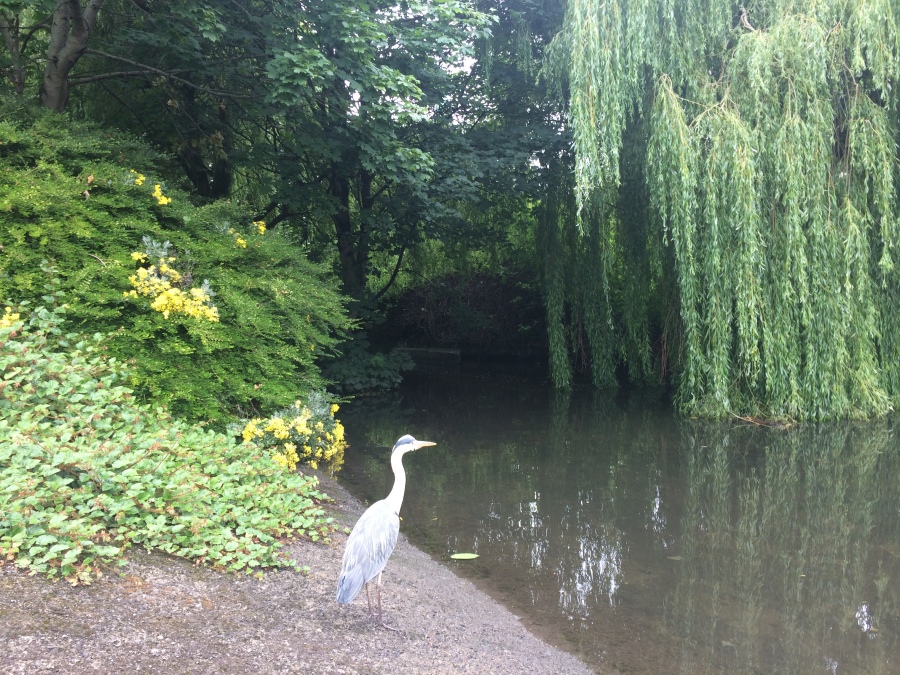
There’s a local pub here called the Stone Boat, the name a nice appreciation of history and the river. The Stone Boat was another piece of medieval river-engineering, more of which anon. You could glimpse of the Poddle down the short curving road beside the picture framing business to peak over a wall. But to get a more satisfying view turn left instead onto Kimage Rd Lower, then after a few hundred meters left again into a nice estate called Mount Argus View. The developer here did a super job here landscaping the river into this estate, making it an attractive amenity and helping somewhat to manage some of the flood risk downstream, which can be significant, even dangerous. I saw heron and ducks here. But although I spent about twenty minutes trying to spot the Stone Boat, I failed. But what is the Stone Boat?
The Stone Boat is an ancient, triangular stone, shaped like the prow of a ship. Other times it was called “the Tongue”. Its role was to divide the river into two branches. One forks North-west, becoming the city water course which historically supplied the City Basin at St James (now filled in). The other fork, right of the Stone Boat goes North-east, and retains the name Poddle. We’ll stay with this one. It passes Mount Jerome Cemetery. If you are feeling fanatical enough you can spot the Poddle in three different places around the cemetery. It runs in a slim channel southward out of the Cemetery behind Gandon Court. It goes through the middle of the cemetery and can be briefly glimpsed over the wall bordering the Muslim burial plot here. Finally, if you can get behind the previous Protestant, now Russian Orthodox church and if (not for the fainthearted this) if you clamber up on the metal contraption beside the wall, peer over and you’ll be rewarded with with the Poddle emerging picturesque from underground, running in its channel along the between the church and cemetery. Wild flowers peak out of the old stone walls of the channel, and very pretty it is too.
The river is soon back below the ground as it continues south towards the city, going under the hospice in the Harold’s Cross / Greenmount area, where it occasionally threaten to flood. Then under the Grand Canal, an unusual but by no means unique case of water flowing under other water. Then beneath the South Circular Road near Griffith College, alongside Raymond Street the far side of the SCR, then in a line just west and parallel to, Clanbrassil Street. All of this is underground. In fact, you won’t see the Poddle again except for two potential sightings.
Back when it ran overground in this area, it used to touch the ends of old, now vanished lane-ways here west of Clanbrassil Street, streets of of saggy old cottages with redolent names like Duckers Lane and Faddle Alley, where the legendary blind Liberties poet Zozimus was born.
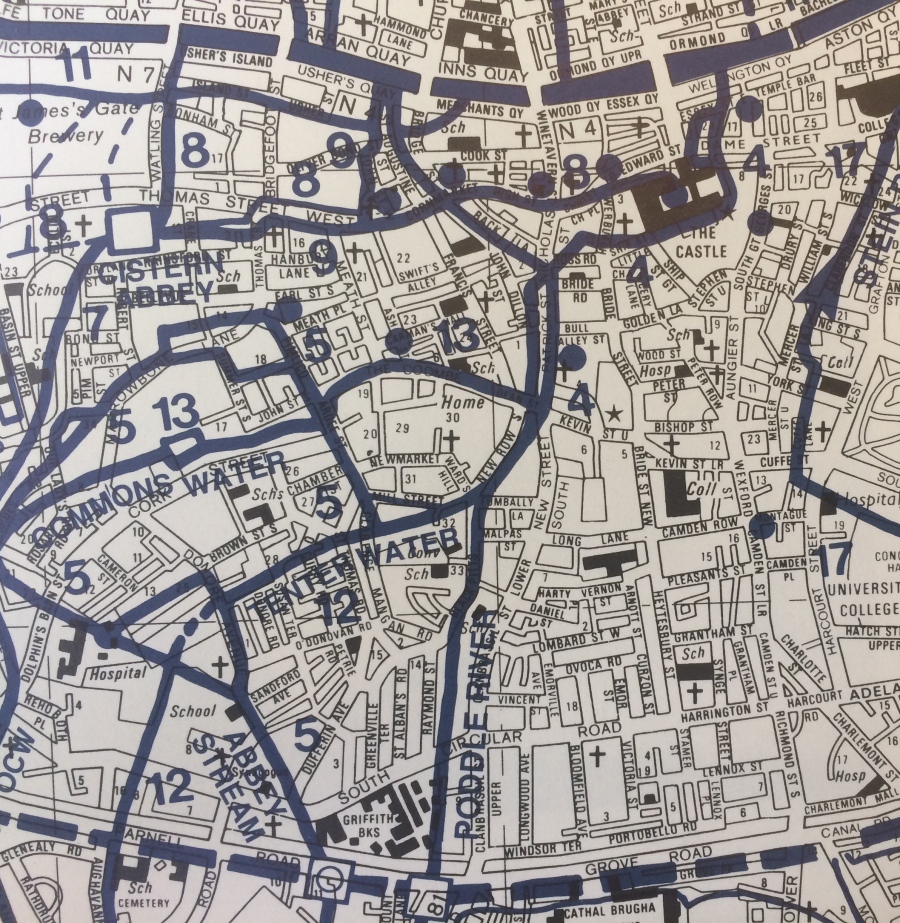
The river now flows north traveling under Blackpitts. This whole area is honeycombed with underground streams, rivers and water courses. Our Poddle meets one called “Tenters Water” at the corner of Blackpitts/Fumbally Lane, then flows past the end of Mill St, up New Row, then meets another watercourse called the Commons Water, underneath where Patrick’s St/ Clanbrassil St meets Kevin St Upper and the Combe.
I’m not even going to tell you what happens just west of here, just south of Mill St. But the name is a hint. The medieval mill maintained by the monks of St Thomas Court was the reason the monks dug that channel mentioned, diverting water from the Dodder in Ballyrotheyback in 1242, (so that the Poddle was strong enough to power the mills here in the Liberities). This whole area is studded with archaeology. Some of this history and archaeology is covered in a separate article about the Mill area, here. But let’s stay with the Poddle and finish the story. At Patrick’s Street near the junction with Kevin Street, the river splits in two. Both branches flow north. Once upon a time, between the branches they sometimes created an island. This once gave the mighty cathedral here the medieval Latin sobriquet San Patricio in Isola.: St Patrick’s on the Island.
These two branches reunite near the western end of the Iveagh Trust flats (at a point underground between Bride Road and Ross Rd) then flow north to Dublin castle. More or less at at the bottom of Werburgh Street when the river hit the wall it’s channeled east to flow along the south side of the city and castle walls . (Remember that the castle itself once was the SE corner of the city) In the medieval era the Poddle was engineered by the Anglo-Normans rulers to wrap around Dublin Castle as a defensive moat. They even dammed it to keep it usefully high. A low moat is no use to anyone. This dam by the way, is where our street name Dame St comes from.
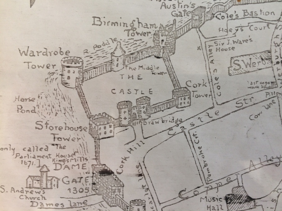
On the far side of Dublin castle, under Palace Street, the river again forks one final time. One branch runs west under City Hall, Dame St, Crane Lane into Temple Bar. Under old redbrick Dolphin House it turns back sharply east, under the Project Theatre, then reunites with the other under Bad Bob’s pub on Essex Street.
The other branch flows from Palace St directly under Dame Street and the Olympia to meets its sibling under Bad Bobs, as described. The reunited river then flows the last few metres, going diagonally under Essex Street, Dollard House, the Clarence Hotel and Wellington Quay to decant out into the Liffey. The Poddle finally join the Liffey, entering via a slightly sinsiter looking portcullis style gate set into the quays, more or less in front of the Clarence hotel.
This gate is visible from Capel Street (Grattan) Bridge. Depending on rainfall, the output here can be a trickle or a torrent. Few casual visitors on the bridge notice it emerging. Fewer still could guess at the odyssey that preceded it. And none could imagine that for centuries the River Poddle provided our drinking water, powdered our mills and kept the city safe from invasion. It was the Poddle, not the salty, tidal Liffey, that provided the water for Dublin’s brewing, tanning, distilling, as well as market gardens and scores of other uses. There’s one other, massive role it played in Dublin’s economy and industry. Long before coal, oil or steam, it was the source of power for nearly all our first mills and factories. It helped build this city. In fact, it’s likely that wihout it, Dublin ever would or even could have thrived. More simply put, there wouldn’t be a Dublin.
All this explains why, once they learn about it, people tend to treat this modest little stream with interest and affection.
That after all, is no more than it deserves.
List of Illustrations.
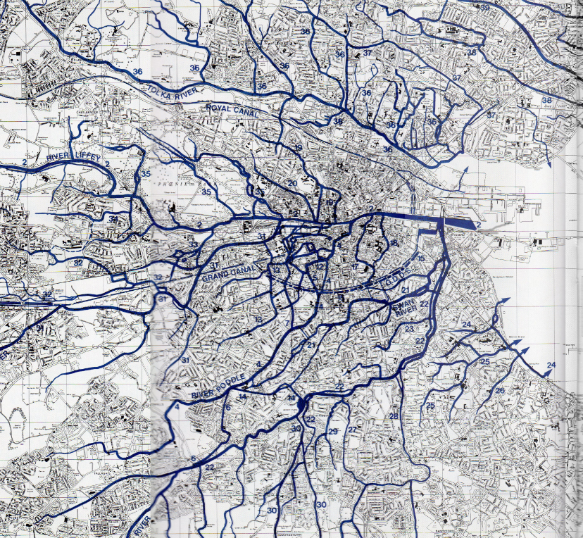
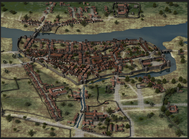
Map A: 1 Detail from a map by Clair Sweeney map, The Rivers of Dublin, DCC 1991
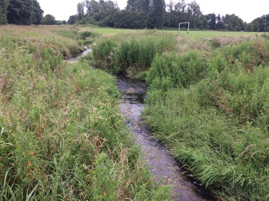
Fig 1 the River Tymon/ Poddle near its source, as it flows out from Tymon Park.
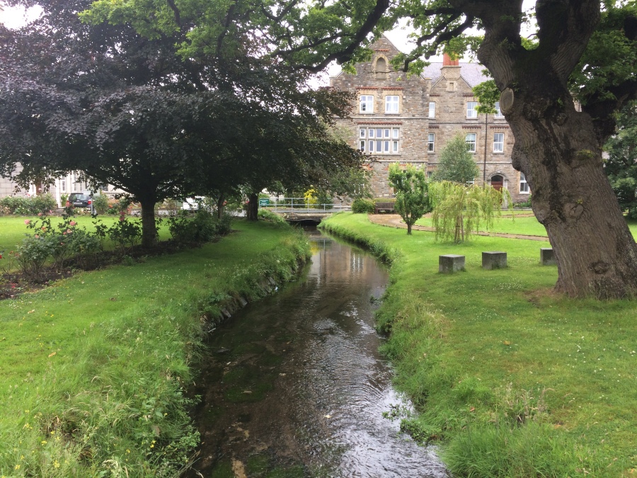
Fig 2 the Poddle at Kimage Manor, about to go underground.
Fig 3- a Heron fishes in the Poddle, at Mount Argus,
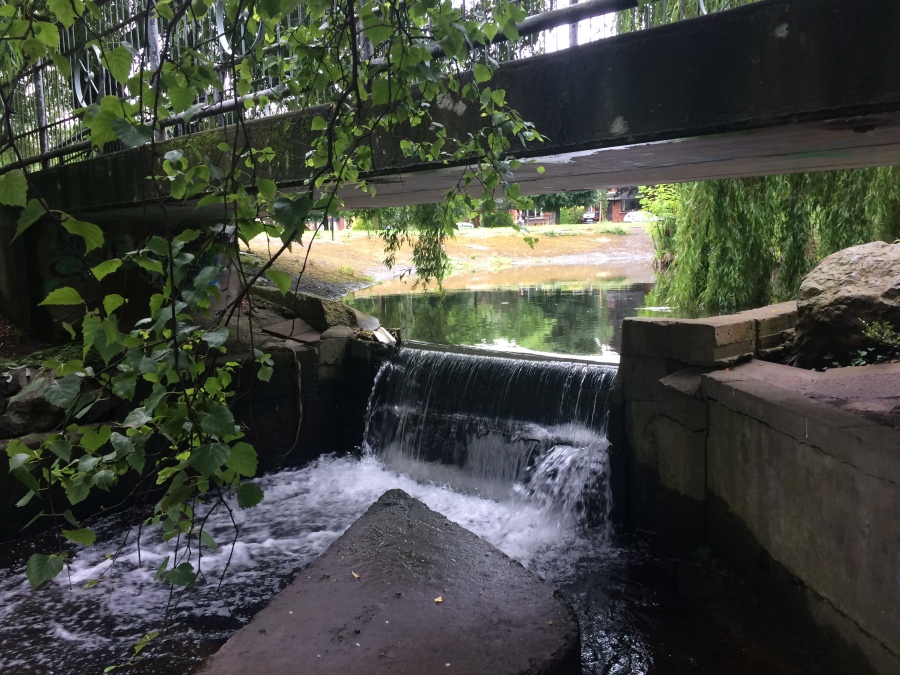
Fig 4- the Poddle flows under Bridge and over a Weir at Mount Argus
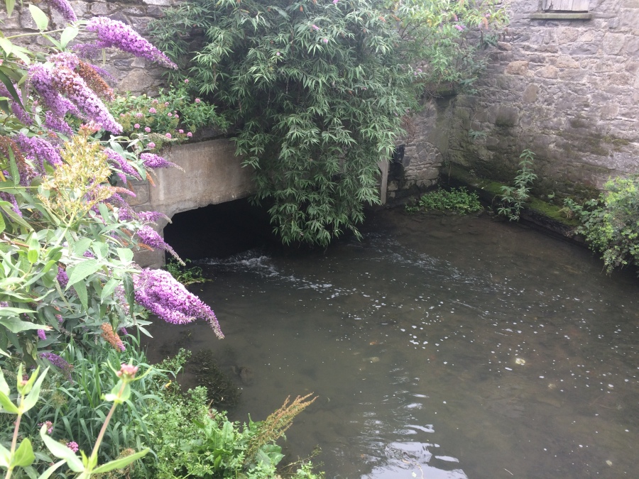
Fig 5- River Poddle flows behind Mount Jerome Cemetery & the Russian Orthodox church there.
Map B: (Fig 6) a section of the Poddle and interlinking water courses in the Liberties area, including Tenters Water and Commons Water. An expanded detail from Claire Sweeney’s book Rivers of Dublin.
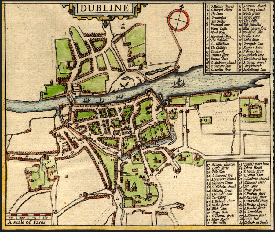
Fig 7 John Speed’s Map of Dublin, from 1610. You can see the Abbey of Saint Thomas Court, (number 58 according to the legend here) behind St Catherine’s Church and in its patch of green, in the lower-
Fig 8 the Poddle approaches Dublin. An amazing artist impression of the medieval City, by Iain Barber. Courtesy of the artist.
Acknowledgements: Thanks to Dr Ruth Johnson, chief archaeological officer at DCC; to Dr Claire Walsh at Archaeological Projects Ltd; to Michael Hayes, online editor Architecture Ireland magazine; to Ciarán Ferrie of the Fumbaly Exchange. I need to acknowledge the large debt owed by myself and this piece to my main source, the wonderful book Rivers of Dublin, pub. DCC 1991, written by late Clair L Sweeney, formerly water engineer in DCC and the real and acknowledged expert in this field. We are all in his debt.
Some people may be interesting in our guided walking tours. Dublin Decoded run both public and private guided walking tours of of Dublin’s built heritage and history: including explorations of the Georgian era, Modern and Victorian, social, cultural and political history and even tours of Medieval Dublin’s walls. To see details of our famous Dublin Decoded public, guided walking tours, to which all are welcome (tickets average €19 pp) please go to the Public Walks page of our tours website. Be advised, we run just 2-4 public tours each month, they are only scheduled 8- 25 days prior to each tour, and they nearly always sell out. This useful monthly newsletter will let you know if or when new public tours go ahead. Alternatively, to see the possibilities for booking a private tour, on a date of your own choosing, for your own group, please go to the home page of our tours website, see the available featured tours, then follow the steps to book your tour. Private tours from €200, for your entire group. All information on our tours is on the respective tour pages.
Either way, whether you join one of our public walks, to which all are welcome, we look forward to welcoming you on tour!

This is fascinating. I had no idea how much of Dublin’s waterways were underground! I am impressed, too, at how long ago river engineering seems to have begun.
LikeLiked by 1 person
Many thanks for that Susie. Yes, i entirely agree. I knew people had been engineering and manipulating the fow of rivers for millennia, but I was still amazed by just how ambitious some of these schemes were. 1.75 miles the Dodder to Poddle diverted branch is. Without any modern, mechanized digging equipment. That is extraordinary I thought.
LikeLiked by 1 person
Hi Arran – brilliant piece! I’ll never look at Dublin the same way again.
LikeLiked by 1 person
Many thanks Finola. Delighted you enjoyed!
LikeLike
Fascinating Aaron, thank you so much. I hope you will consider giving some more data/history on the other Dublin ancient waterways, such as the Blessington St Basin, which provided the water for our old distilleries. Whilst not rivers, I would love to see both the Grand & Royal canals given the protection & prestige of being declared 2 linear National Parks, within our NP portfolio.
LikeLiked by 1 person
Many thanks for your kind words John. I’d also love to see the basin and both canals given additional status and protection. I may adopt your suggestions and write on each of them in future articles in future months. Many thanks – Arran.
LikeLike
Brilliant piece, brings Dublin of long ago to life.
LikeLiked by 1 person
Many thanks Andrew. Very kind of you to say so. I’m thrilled so many people seem to be enjoying this. Many thanks for taking a moment to say so. Very thoughtful.
LikeLike
Poddle must be the best, most affectionate name for a river ever. What does it mean?
LikeLike
That’s a very good question Jane, and I’m afraid I can’t provide a definite or certain answer. But off the top of my head, my best guess is that it may, perhaps, be middle English. (?) If so- then the name may well have the same sense as “Puddle”. Dublin of course was founded by the Vikings but then from 1170, was developed, much more extensively, by the medieval Anglo-Normans. Henry II got the ball rolling, when he “gave” Dublin to “his men of Bristol”, basically providing various privileges and prerogatives and reliefs from various taxation and duties, essentially to try and kick-start the economy and to try to encourage both immigration and trade. It actually worked, for the first 115 years or so, when the economy was very buoyant. Anyway, many people, especially merchants, came over from England, in particular from Bristol and from Chester. For all these reasons, one of my favourite writers on Dublin, Peter Summerville-West, speculates that the local patois in Dublin back then was a sort of west country and/or NW burr, in the speaking style of say, Geoffrey Chaucer. It’s an image I’ve always enjoyed, and he provides some textual evidence, in a few religious “Mummer plays” that have survived to us from that era.
Anyway, forgive the slightly long answer! But it gives us a sense that Poddle, may be a corruption of Puddle, and may, possibly, derive from Middle English. But as I say, I could easily be completely wrong about all that. We’ll probably discover tomorrow it’s actually derived from Gaelic!
LikeLike
The reason I asked was because I thought Old English from the Norse or Saxon sound of it. The Viking connection could explain that, although I have a feeling puddle is more Germanic than Norse. Anyway, it’s a lovely name for a poddling pottering pootling river 🙂
LikeLiked by 1 person
You can often see the Poddle at the intersection of werbergh-bride st and little ship st/Ross rd – whenever it rains hard it comes up to create a big puddle (sometimes a proper shallow flowing stream) there. I used to live just above it for years – thanks for giving its full route, I’ll go and walk that – very interesting history! Thanks!
LikeLiked by 1 person
ah ha, good to know. That is very interesting Helanne. Because of course, that’s exactly the point where those two branches that split around St Patrick’s cathedral, re-meet again. So in one way, it makes complete sense it would flow a bit faster and stronger here, with the potential for occasional flooding.
Although, in another way, I’m slightly surprised it floods there, only because the land is rising at that stage as it climbs the hill towards Christ Church, and of course the river isn’t (can’t really) flow uphill, which means that it (Poddle) is instead going deeper and deeper underground, relative to the surface of the road above it. Still, if you say it floods, then obviously it does. The river can be in full spate at times, with huge pressure building up underground. I believe the flood management civil engineers of DCC have a constant battle on their hands!
Many thanks for your comment and interesting information. I recommend walking the full course of the river. With a friend if you can. (There a re few adventurous bits!) If you do the full thing it takes a few hours, but I really enjoyed it. Hope you have a ball.
LikeLiked by 1 person
Hi thanks for the reply – it floods often there – when it flows, it flows downhill on the surface into the drains on Ross Rd/ship st. There is a distinct (relately) dip in the roads there, some surface microtopography that either marks the river channel or the drain route. I’m not sure if it is the river alone, because this is immediately outside the old walled city gate, where maps show a bridge – not clear to me if that’s over the river or a drain built outside the walls.
I would also be interested in knowing how the baths (now iveagh fitness) relate to pre-18th century, if at all.
LikeLike
Many thanks for your reply in return. I think the Iveagh baths were purely an innovation of their own time, (I mean without any specific 18th C historic precedent, nothing specific to that immediate area) They were more part of the overall philanthropic v late 19thC/ v early 20thC slum-clearances and philanthropic re-housing schemes in the area undertake by Guinness family/Iveagh Trust, like the Iveagh Flats; Iveagh markets; St Patrick’s park and the “Baeno” day care centre. .
To touch on your other query, re ditch v river, the river as you know has been, endlessly engineered and re-engineered, not least by the defenders of Dublin castle, who routed it around 3 sides of the castle, with a fourth side lined by a ditch, (which could also be flooded, at siege times, via the use of a sluice gate) Very interested to hear about that Bridge on map. Would love to find and to see see that if possible. Can you by any chance recall which map it was you saw that? Or if you had access to a reproduction I’d be v interested.
LikeLike
Lovely article. I have to walk the route sometime. It’s a great river with such history and contribution to the Dublin’s society and life over the centuries. And it also enabled and provided the escape conduit for Red Hugh O’Donnell’s two escapes from the Record/Wardrobe Tower of Dublin Castle (the only person to successfully escape from there).
LikeLiked by 1 person
Very interesting about Red Hugh O’Donnell. I don’t know nearly as much about that whole area as i should. I’m trying to learn as I go along.
Delighted you enjoyed the river piece anyway. And many thanks for taking the time to comment, very kind.
-Arran.
LikeLike
Thanks you so much
I learned a lot of the hidden rivers
LikeLiked by 1 person
my pleasure 🙂
LikeLike
thank you for this article. I had always referred to the part running across SCR to Donore to the Tenters as the Poddle. Now I know!
LikeLiked by 1 person
My pleasure. Delighted you enjoyed! Come on one of our public walking tours sometime. They re-start in September. You’d love them! https://dublindecoded.com/public-walking-tours/
LikeLike
Amazing stuff. As a Surveyor who has for some 50 years been dealing with insurance claims for ‘alleged’ subsidence to properties I had a great introduction to ‘underground’ rivers when carrying out underpinning to a damaged property on the Ballymun Road some 40 years ago. Having just bored through the foundation to insert a pile we heard the sound of running water – looked through the hole to see what was underneath – it was a river and that sent me researching Dublin’s underground rivers and go copies of Clair Sweeney’s maps. I think it was the Wad river but i’m not sure. I now have all the maps and your post enlightened me so much more. Thank you.
LikeLiked by 1 person
Delighted you enjoyed it. Thank you for your kind words. That’s a great story about seeing the river running directly under that property.
Do come and visit us again.
Very best wishes- Arran.
LikeLike
Also to add to this the Poddle splits at the back of Templeogue College (Kimmage Manor) and the water from here goes underground to the Lake in Terenure College. From here it goes into a culvert to Bushy Park and comes out as the waterfall in Bushy Park. In the last few years the water has been diverted away from the lakes in Bushy Park and runs straight into the Dodder river above the stepping stones. I have always wanted to see the actual course of the culverts but they don’t appear on any maps. You can see from the old OSI maps free on their website the different lakes and water courses that the river takes but they do not show the culverts.
LikeLiked by 1 person
That’s all great stuff David. Thank you for your comments and additional information. – Arran.
LikeLike
Hi arran,
I walk in st annes park most days and it was when i googled to try find info about the nanokin ( which i never knew was named after the Nanny) that i came across this wonderful story of the poddle.
It sounds like a lot of hard work researching it! Well done.
Have you thought of doing a walking or cycling tour based on this research?
Or do you do talks for groups like local history etc?
LikeLiked by 1 person
Hi, delighted you enjoyed the piece. And yes, we have thought about doing a walk along the route of the Poddle, from its source right into the city centre where it empties into the Liffey, even though its a very long way!
If we go ahead then we will definitely put it on our other website dublin decoded .com (Always on the Public Walks page of that website) And by the way if you like historic walking tours, please see the same Public Walks page, of that same website. Because there are 3 walks coming up in the next 12 days alone: including one the day after tomorrow (as I write) I mean on Wednesday 15 July.
Come along: you’d love it, al lot of it is about rivers, quaysides and bridges!
ALL the info is on that same page. Join us!
-Arran.
LikeLike
Well, I thoroughly enjoyed that. Sneaky one: the Poddle (though really, I have now learnt from you, the “Tenter Water”) pops up in Warrenmount Convent grounds rather prettily. The gates are often open. Alas, the student accommodation on Mill St built a cement bridge over part of it and keep their gates locked. Boo to that.
Thank you for the lovely article.
LikeLike
Thanks Jane, delighted you enjoyed it.
If you’d ever like to consider coming on one of our historic walking tours by the way – (including one walk route that covers this Blackpitts- Newmarket area) – then please do have a look at our other website some time? It has all our history and architecture walks listed on it. dublindecoded.com
Thanks again for the nice message.
And yes, a big boo to concrete bridges over ancient rivers!
best wishes
-Arran
LikeLiked by 1 person