
Recently we looked at John Speed’s 1610 map of Dublin, a crucial source for historians. This week we look at a map by a historian. It’s Leonard Strangeway’s 1904 The Walls of Dublin. In other words, depicting the medieval city and walls, but made much later. Here it is. It’s worth pointing out that unlike most other maps, Strangeways’ map is “the other way round” so just bear in mind here on images below that South is “up” and North is “down”.
The author focused on the city’s ancient defensive walls, seeking to locate their exact lines, (no easy task) and also includes fascinating valuable information on the location of buildings from the medieval era, say from c1170 right through to (in Dublin’s case anyway) maybe 1600. He also includes also buildings from the early modern period (say c1600 to early/mid-1700s, when the Georgian period began.) The walls of course date from much earlier, built from c1170, in the immediate aftermath of the Anglo-Norman conquest, replacing the wooden stockade Dublin’s previous Hiberno-Norse inhabitants used for defense.
Our 1904 scholar was one Leonard R. Strangeways, of the Royal Irish Academy. One of many delights of his map is the way he notes his sources with the succinct words “From all available authorities” Blunt and confident, but as fsar as i can gather, seemingly true.
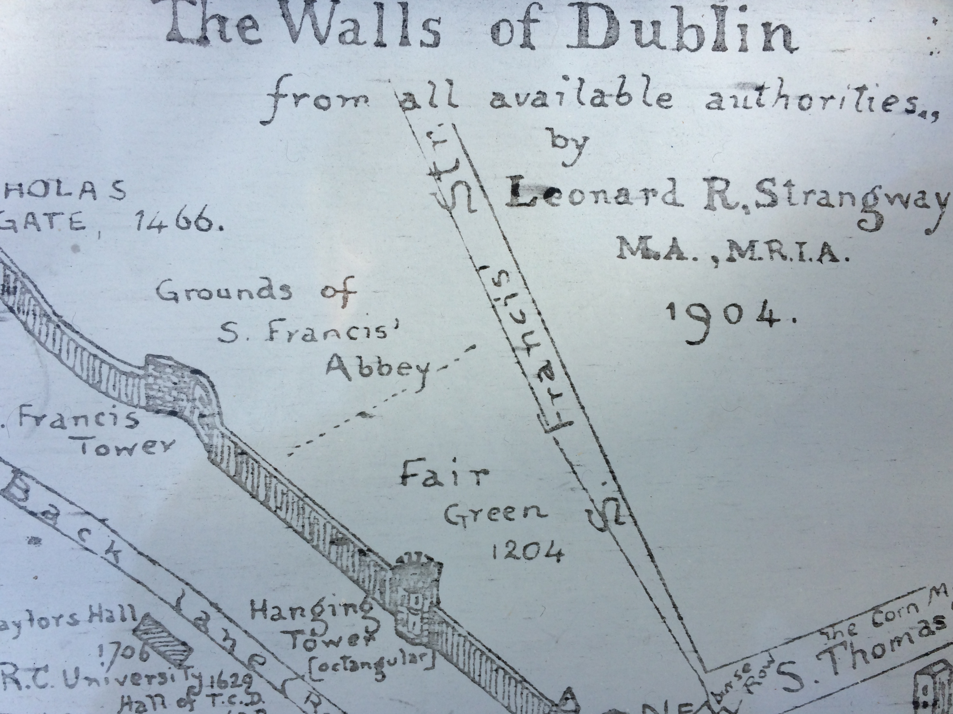
In setting out on this project to locate vanished walls and long-gone buildings, Strangeways confronted a complex task. Unlike intact medieval cities like say, Venice, or Bruges, medieval Dublin has on the whole simply disappeared. It has been swept away by age, by war, neglect, damp and decay, by the Wide Streets Committee (from 1753) and other more recent, often far more brutal developments.
So what, if anything is left of ancient Dublin? Well, the great Maurice Craig’s famous book Dublin 1660-1860 is a good place to begin. In the introduction he sets out a sort of “medieval-survivors” inventory. He lists parts of Christchurch and Saint Patrick’s (albeit both heavily restored in the Victorian period) and parts of Saint Sepulchre, which is of course the Archbishop’s palace beside Saint Patrick’s, (nowadays this is Kevin Street Garda station) and a few other fragments.
The City Walls The city walls themselves, built in the 12th &13th centuries, were mostly pulled down in the late 1600s. We have references to specific demolitions in both 1688 and in 1699. The Dame Gate for example, (built 1305) and its surrounding walls, were all pulled down 1699, and this demolition may well have included Isolde’s Tower nearby. Incidentally, Strangeway has made a small, entirely-understandable error depicting Isolde’s tower as a square-cornered structure. The foundations seem to indicate it was round, but of course Strangeways would not have had access to these in 1904, as we do today.
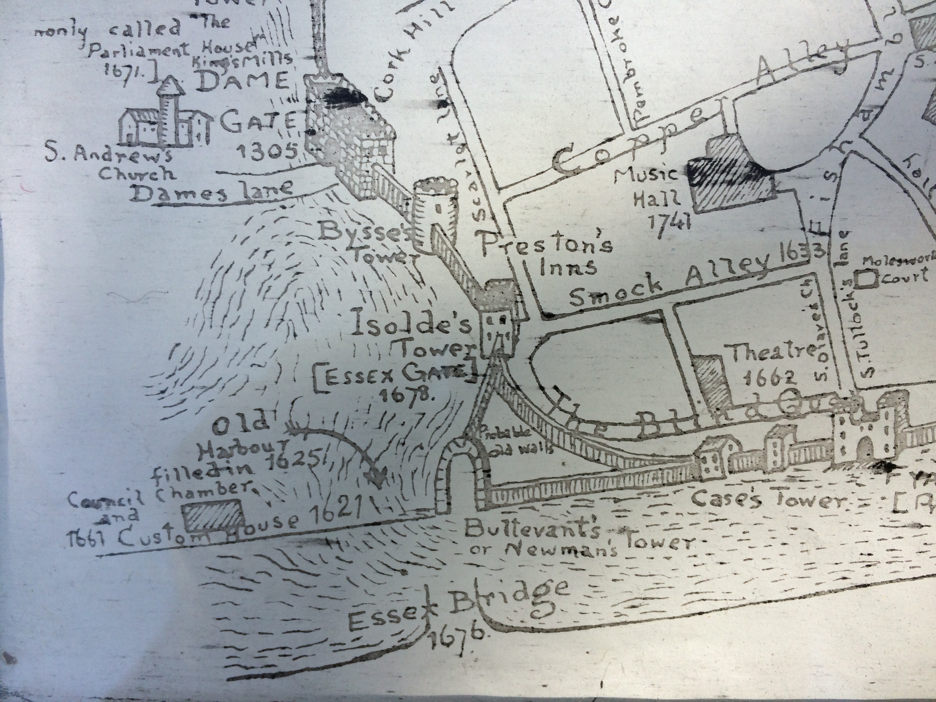
By this period around the 1690s, following advances in artillery and cannon, defensive walls were largely obsolete. In a specifically Irish political context, it’s also no coincidence many of the walls came down after victory in the Williamite war (and the following “Settlement”) both of which made the crown authorities, city fathers and Dublin merchant/professional classes (by now almost universally Protestant) feel physically and politically secure. No more use, or need, for walls.
Craig notes the large medieval wall section still standing today at Cook Street, adding, “Not nearly so bogus as it appears”. He meant that it has been repaired from time to time over the centuries, but yes, it is authentic. Very old buildings are consonantly being repaired and altered acrross the centuries, indeed it’s part of their very nature, something i try to impress on visitors here occasionally.
By the way, this particular rectangle of walled city above was basically an extension, reclaimed from the river by the Anglo-Normans in the medieval period, creating a new Merchants Quay, (where Stangeways has written “New walls”.)
I’m fascinated by the various references to Jesuit Meeting halls etc; and utterly puzzled, and particularly intrigued by the enigmatic words elsewhere on the map that appear to say “RC University 1629” I won’t digress into it now, but if any historian or scholar out there has further information, I’d be very, very happy to hear from you.
Anyway, lets get back to our survivors list. To this large intact section shown above at Cook Street, Craig might have added another large length of wall along Ship Street by the Castle; another running along Lamb’s Alley; plus smaller additional fragments in the Liberties.
These are admittedly just the “above ground” sections that endure. Cities are full of underground mysteries, from buried buildings and tunnels to underground rivers. There are other sections of city wall below the current surface we all know today. Notably the part excavated by archeologists in the 1970s and 80s, during the Wood Quay digs. This by the way is now visible and accessible, in that underground room used for conferences by Dublin City Council. Visit when you can, and you’ll see each stone there has been numbered.
To conclude with “Craig’s List” (if that’s not blasphemous to the great man) he also listed a few survivors which strictly speaking, are artifacts, (rather than walls or buildings) including medieval sculptures like the Portlester memorial in St Audoen’s, (there’s another medieval work, a tomb, in St Werbughs). But the point about the “Medieval Survivor list” overall is basically how short it is. As I say above, most of medieval and early Dublin has vanished.
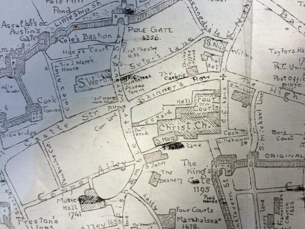
And that of course, is exactly what makes Strangeways’ map both so fascinating, and so amazingly useful to people like myself. His map rewards close attention, in many ways. Look for example, at just how much the area around Christ Church has changed.
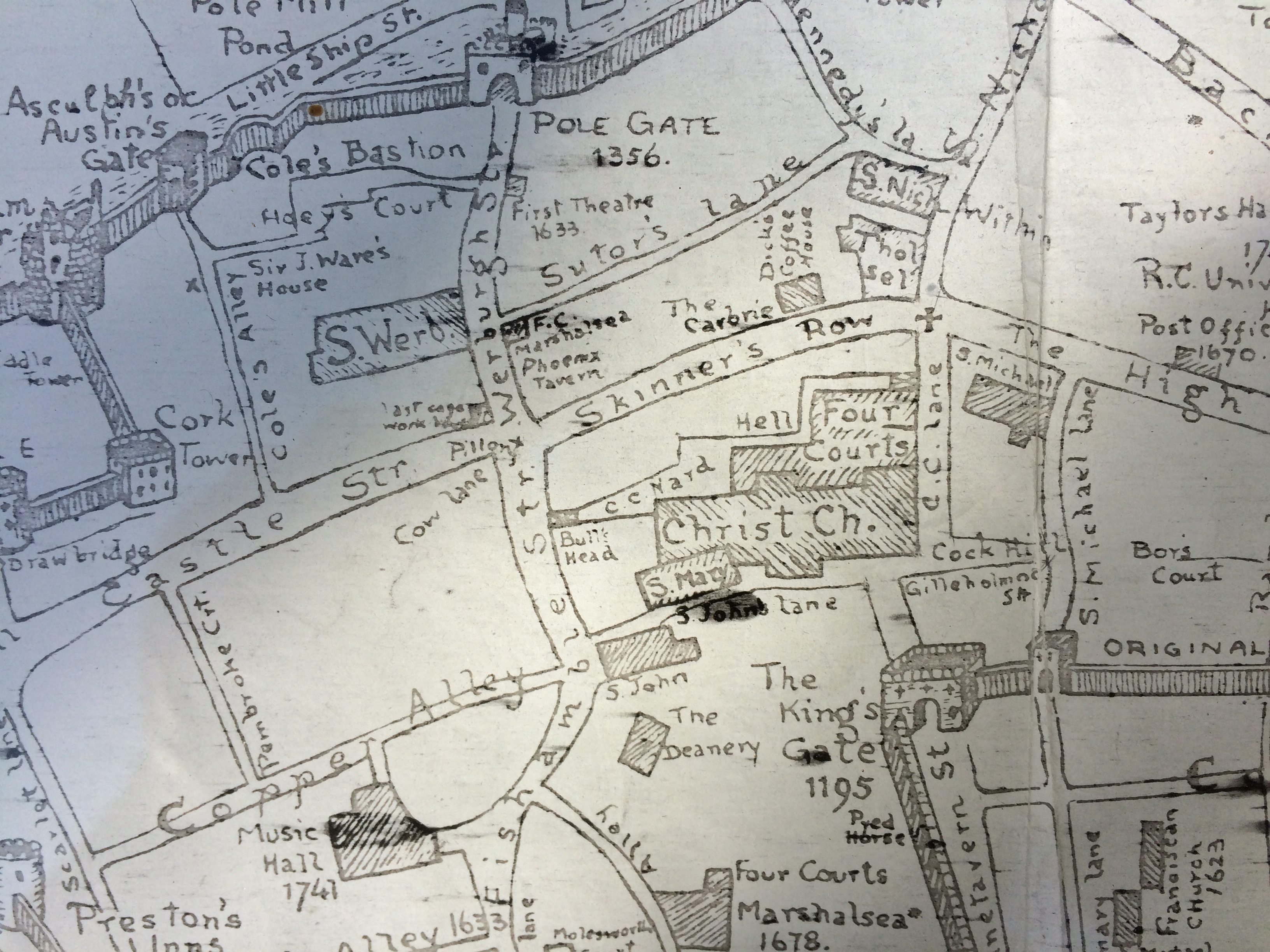
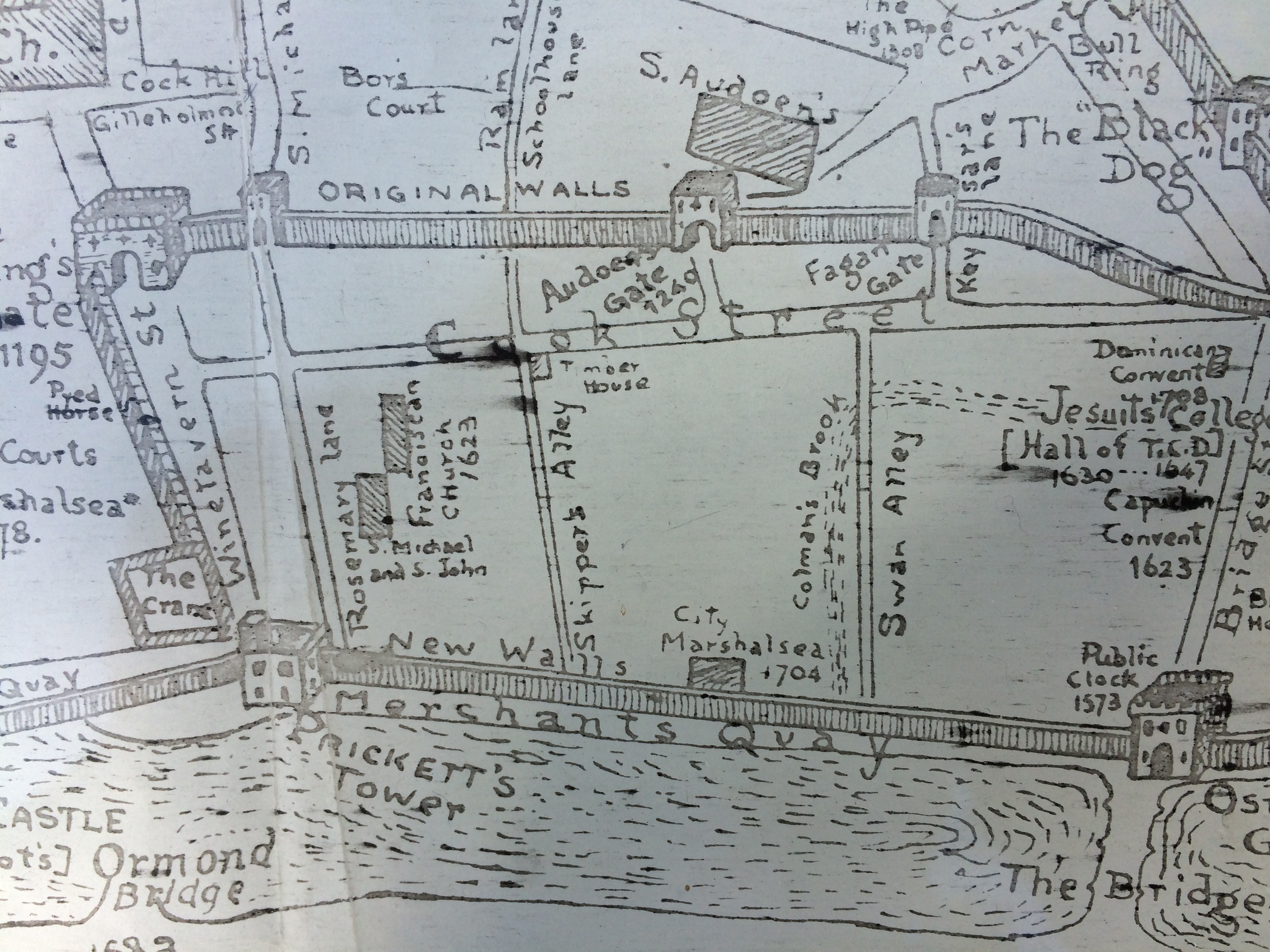
Immediately attached to Christ Church as you see, is the Four Courts, obviously no longer there today. (we’ll come back to that in a moment). Also attached is S Marys church, also gone. Immediately to the west (right here) is S Michael’s: gone. Below it (North here, disconcertingly) is the Kings Gate, gone. Near St Mary’s was St John.s (gone). Beyond that is the CC Deanery: gone, from here at least, (I believe the CC Deanery today is a house by S Werburgh’s). On the far side of Skinner Row, (which itself has gone or at least been changed beyond recognition) is the old Thosel, (once used for civic and trade meetings) and beyond that is St Nicholas, both gone. All changed, changed utterly.. as Yeats might have said. That church is called St Nicholas Within meaning wihin the walls, there there another called (honestly) St Nicholas’-without. Even from that one clue, you can sense how important the city walls were to medieval citizens, how they referenced them constantly in daily life, navigated and orientated themselves for centuries, by their lines and their constant, reassuring presence.
While the walls and many of the buildings have vanished, in some or many cases, the institutions once housed by those building have not gone, but have instead relocated, in what we might call “the Migrating institutions phenomenon”. In other, less high-fallutin’ words, we can see how institutions like the Four Courts; the Kings Inns, and various version of the Customs House have moved around the city over the centuries.
Look at our map again now. See how the old Four Courts (centre of image, below) stood directly in front of Christ Church cathedral. Conversely, the Kings Inns stood where the Four Courts is now. (down by the river, on the old site of Saint Saviours and current site of Four Courts) Admittedly Strangeway does not show the riverside Inns on his map, but Speed does, in his 1610 work. You can see it below, it’s numbered #3 in his legend in the panel to the right and on his map itself.

So we know, (both from Speed 1610 map, and from other, written sources) that the Inns were where the 4 Courts stand today (although not of course in the same building). The current Four Courts only date from the late 1700s, designed first by Thomas Colley then, (after Cooley’s death) by James Gandon.
My favorite example of “Migration” is the Customs House. Or rather Customs Houses, as per different manifestations across the centuries. As Dublin is a port and trading city, the Customs House was naturally a vital focus of commercial activity. Indeed it was a focus of city life in general, particularly prior to mechanization, when it would have employed large numbers of labourers, and right in the city centre too.
The old Dublin vernacular for this key institution by the way was not “Customs House” but “Crane House” or simply “the Crane”. Look again at the area around Cook Street, at the NE (lower-right) corner and as you can see, the original one- the old Crane- stood on Wood Quay… abutting the walls of the reclaimed city extension, mentioned earlier.
Or at least it did, until it was blown to pieces by the massive gunpowder explosion of 1597.
For those who may not know the story, barrels of gunpowder were being unloaded at the old Crane, They’d been shipped over from England, for use against the Great (Hugh) O’Neill and in his allies, in the 9 Years War. Then a spark ignited one of the barrels. Within moments the whole lot exploded, blowing the old Crane House to bits, killing the poor old Crane house officer John Allen and his infant son, (the Allen family lived in the building) and killing perhaps 100-120 other people in the vicinity. God knows how many hundreds more were and injured and maimed.
The shock waves were enough to blow apart the old Elizabethan merchants’ cage houses that lined both sides of the river. It also caused a large crack in the stone bell tower of Saint Audoen’s Church, a crack that can still be seen in there today.
Naturally, suspicion fell on enemy intervention, although anyone attempting sabotage like this would have had to been prepared to die in the attack, making them an early suicide bomber. Ultimately this theory was discounted by the official enquiry. The whole thing was written off as a huge, horrific accident. A spark from a horse’s shoe was blamed in the end.
The enquiry also found, and heavily criticized the fact the powder was only single-casked, not in double cask barrels, as gunpowder was always meant to be. This tragedy would have been appalling in any time, but must have been devastating for the city at the time, bearing in mind that 100+ victims was a significant proportion of the population overall.
But paradoxically, it later helped modernize the city. With so much war, and political instability, the economy was often pretty stagnant from 1597-1660; so much of the area was not rebuilt in that period. That all changed however 70 odd years later, after the end of the Puritan Commonwealth period, with the Restoration of the Stuart dynasty, when James Butler, Duke of Ormonde, returned from exile (with Charles II) to Dublin as Viceroy in 1660, stepping from his coracle onto the sands of Dublin bay as ordinary folk chanted, “You have brought the sunshine with you” (according to Craig’s terrific introduction to his 1660-1860 book), The devastation of the 1597 explosion meant Ormonde now had a blank slate to work with. This in turn meant the development of the Dublin Quays.
Previous houses from the medieval and Elizabethan period had backed directly onto and over the river, using it as a sewer in fact. Ormonde now ordered that all houses be set well back, creating the riverside streets, the quays on both sides of the river that we know today.
Let’s have another closer look at the map and see what else we can learn… We’ve already seen that up to the time of its violent destruction, the old Crane House stood on Wood Quay. After the explosion, the rebuilt version of the Customs House/Crane moved down the river a hundred yards or so, to a point just east of Essex Bridge (today called Grattan Bridge and/or Capel St Bridge) The new Crane/Customs House was near to the Old Essex gate and Isolde’s Tower, which were both still intact and standing at the time. Can you see it below? This is version 2 of the Customs House Crane, in its new position.
You’ll also see that there used to be a harbour, behind the “new Customs House” – a harbour fed of course by the Liffey. But also presumably fed by the river Poddle, via the old dam that lay just outside the Castle and the Dam Gate (or Dame Gate). In these parts, the Poddle was engineered to form a moat for Dublin castle. This dam was the terminus of that system, dammed to keep the level of the Poddle/moat high enough for defense.
The harbor itself, basically an inlet off the Liffey, was filled in 1625 Strangeways tells us here with his handwritten annotation visible above.
This “Pill” was just one of several old harbours that used to lie off the Liffey. The old Dublin vernacular for a harbor was ”Pill” The monks at St May’s had their own Pill too, where the Bradogue river (now covered up) met the Liffey. This St Mary’s harbor/Pill is where Sir William Skeffington landed, when arriving in Ireland in 1535, sent over by Henry VIII to deal (brutally) with the Silken Thomas Rebellion.
There is a another, different Harbour visible here on Stangeways map, further west. (see below) This is Usher’s Pill, named after the old Dublin family of that name. They had a great town house on Usher’s island. This is the family who gave us James Usher, the archbishop-philosopher who, very accurately, calculated the creation of the world to 4004 BC. 🙂
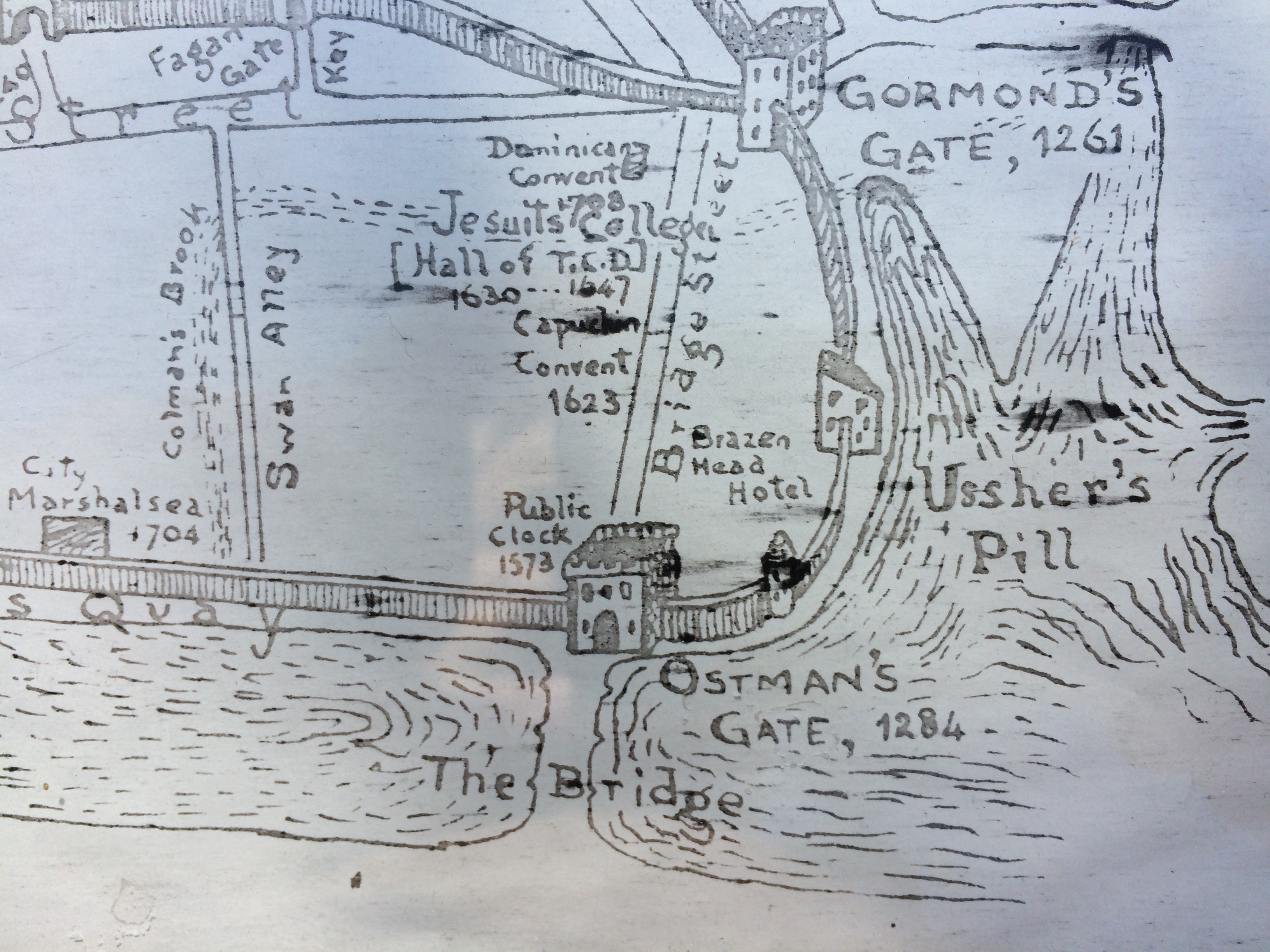
Getting away from various Pills, on this section of the map below you can also see the Brazen Head Hostelry, Ireland’s oldest pub. It is, miraculously, still serving pints of grog to this day. You can also see “the Bridge”, as you can guess it was simply called that because for centuries it was the only bridge. There were various attempts to build other bridges, but up to the late 1600s, all such plans floundered, mostly in the teeth of opposition by various private interest groups, such as ferrymen. The common good defeated by sectional interest groups, hmmm.. sounds familiar. Plus ca change, and all that.
Getting back to the replacement Customs House, Strangeways gives 1621 as the date. Presumably there was some makeshift arrangement in place for those 24 years between 1597-1621.
Later again of course, much later, in the late 1780s-90s, a third Customs House went up, much further down the river, at the behest of the all-powerful John Beresford. This is the magnificent neo-classical Georgian edifice by James Gandon we all know today.
That wonderful building was gutted by fire in the War of Independence, was later repaired, and the Customs office operated from there most of the 20th century.
Later on, customs offices operated out of Castleforbes St much further east again (echoing the general eastwards drif of both Port activity and the Customs House over the ceturies) And today, from 2006, from Promanade Road in the modern Dublin Port area complex. So by my estimate, the Customs House has had at least five locations since 1590, and three in last century alone!
If you’d like to go for a walk some time and learn more about medieval Dublin, some readers may be interested in one of our Dublin Decoded walking tours.
Dublin Decoded run both public and private guided walking tours of of Dublin’s built heritage and history: including explorations of the Georgian era, Modern and Victorian infill, social history and even fragments of Medieval Dublin. To see details of our famous Dublin Decoded public, guided walking tours, to which all are welcome (tickets average €19 pp) please go to the Public Walks page of our tours website. Be advised, we run just 2-4 public tours each month, they are only scheduled 8- 25 days prior to each tour, and they nearly always sell out. This useful monthly newsletter will let you know if or when new public tours go ahead. Alternatively, to see the possibilities for booking a private tour, on a date of your own choosing, for your own group, please go to the home page of our tours website, see the available featured tours, then follow the steps to book your tour. Private tours from €200, for your entire group. All information on our tours is on the respective tour pages.
Either way, whether you join one of our public walks, to which all are welcome, we look forward to welcoming you on tour!
Thank you for reading -Arran.

Hi Arran, not sure if you got my messages via Facebook? Hope all well, Turtle
Turtle Bunbury
LikeLike
Endlessly fascinating Arran, thank goodness for you, Turtle and all other modern Irish historians who bring the past to vivid life. But how much lies just beneath our feet, not only in Dublin and elsewhere? Generally we only find out when someone has cause to dig roads, construct offices (Wood Quay) etc. The earth retains more than enough mysteries to see us out.
LikeLiked by 1 person
Great to hear from you Roy, and you’re 100% right of course, about the “:buried” point. Vast amounts, of course. I attended some lectures with Dr Vincent Butler last year who was one of the main archeologists on the 1980s Wood Quay dig, and, apparently, the layers of houses in that area alone, was about 7-12 layers deep. (!)
My favourite example though, is probably the old Chapter House of St Mary’s Abbey. For about 200 year + everyone had assumed it had just been destroyed, along with the rest of the Abbey… until it was rediscovered, under Capel St! 🙂
(And don’t get me started on the rivers!)
You must join our mailing list Roy, just in case you’re ever in Dublin and your trip coincides with a tour. There are links to the sign up form, all over the Dublin Decoded website, hope you’ll join us some time. This should get you to the newsletter if you’d like to join in. http://dublindecoded.com/contact-us/
my very warm regards-
Arran.
LikeLike
[…] Dublin historical maps. […]
LikeLike