
Fancy an amble through the leafy area of Dublin 4, from the RDS, over the Dodder at Ballsbridge and onward to the banks of the Grand Canal? In February 1916, myself and the writer and historian Hugh Oram designed a walking route through this area of Dublin 4. The aim was to commemorate the 1916 Easter Rising, focusing on aspects of it around this area of Dublin. The fighting was fiercer here, and more British causalities fell here, than in any other place during the Easter Rebellion.
We were assisted in our project by a grant from the Dublin City Council 1916 Commemoration Fund, allowing me several precious weeks of research. Once research was complete, the same grant also allowed me to lay on walks of the route free for the public on three dates during March to May 2016.
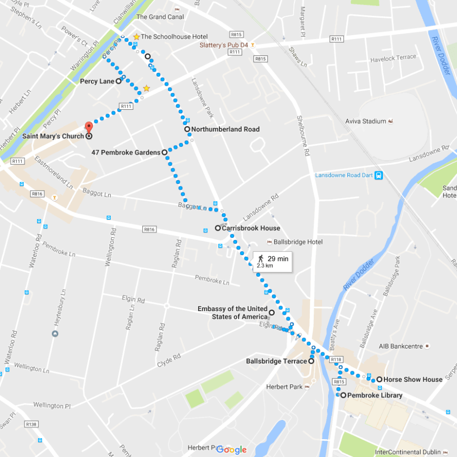
The walks are over now. But we’ve always intended to make a simplified walking route available to anyone wishing to walk it and follow the notes it as a self-guided tour. The notes below suggest where to stop and look, focusing mostly on 1916 history, but with some general, local history, and a few bits of architecture thrown in. The route is arranged in a SE to NW direction, as that’s how the Sherwood Foresters went, and is most effective in telling the story of the Battle of Mount St, as it unfolded in stages. It is of course possible to do the route in the reverse direction, should you wish.
It is not currently possible to add the the notes below as a pdf on this blog alas. But you are very welcome to take a screen grab should you wish. There is also a useful map showing the route. I have reproduced it at several point among the notes below. You may of course also scan or take a screen grab of this map and are welcome to copy it and print it out. Below are the stops and the notes. We hope you find them useful and get a chance to do the walk sometime.
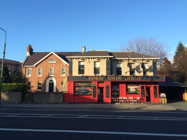
- Begin at the Horse Show House on Merrion Road. (above) Named for the famous horse show that takes place near here every year, just across the road in the RDS (Royal Dublin Society. Cross the road (carefully) to the RDS, (as per map below, near lower-right corner)

- The RDS, founded 1731, is the oldest Philanthropic society of its type in the world. Along with the horse show, the Agricultural Spring show is probably the best known of its annual events. It was just about to begin in when the Rising broke out on Monday 24th Like everything else in the city, plans for the show were thrown into chaos as fighting intensified, communications were severed, and then as martial law was declared. To be clear, the present building was not extant in 1916 as the RDS main headquarters was still in the city center (in Leinster House, Merrion Sq). But the RDS already owned this site on Merrion Road and it was the location of their Agricultural show. This highly salubrious area was, in the main, staunchly Unionist in 1916. So it’s no surprise that the Sherwood Foresters were hailed as heroes as they marched here, from their arrival by ship in Dun Laoghaire (then Kingstown) or that they were then given refreshments by the Society. In leafy Dublin 4, cheered by crowds, a world away from the mud and blood of France, it would have seemed inconceivable that scores of the troops would be killed within just a few hours. After the Rising, a week later, many of Eamon De Valera’s 3rd battalion, following surrender at Bolands Mill would be interned here for processing.
- Right next to the RDS is the old Pembroke Town Hall, (below) Now the HQ of the City of Dublin Education & Training Board. Architect E.H. Carson. Paradoxically it was designed therefore by the father, of “the father of” modern Ulster Unionism. (as Edward Carson, son of the architect is often described) An ironic place for the republican De Valera to be imprisoned.

Because this is where De Valera himself (unlike his men) was held for two days following the surrender of his 3rd Battalion at Bolands Mills. Specifically he was held in the former weighing room here. (It is no longer extant) Due to the chaos across the city, De Valera was held here, as opposed to across the far side of the city in the Richmond Barracks, where Pearse, Clarke, McDonough et al were all held and quickly “processed”. It’s very possible this two-day delay helped save De Valera’s life. General Maxwell, notoriously, processed the other leaders very quickly, in court martials. It was a fatal political error, with huge repercussions for Anglo-Irish relations. Sensing the damage done, Prime minister Herbert Asquith told Maxwell to stop the executions, which Maxwell reluctantly did, only on the day Dev was scheduled to be shot. Thus De Valera escaped being executed only by a hairs breath, indeed almost on a whim. Along with Thomas Ashe, he was the most senior commander to survive 1916. He went on instead to live into his 90s, and more to the point, during that long life become the dominant figure in 20th century Irish politics. Such are the fine margins, and the whims of fate.

above, Éamon De Valera, immediately after his surrender at Boland’s Bakery (not Boland’s Mill, as sometimes reported) Boland’s Bakery then stood on Grand Canal Street, at the junction of Macken St. – roughly opposite the old Sir Patrick Dunn’s Hospital.
- Just around the corner from the old Town Hall, on Anglesea Road, which faces the rover Dodder, is the Pembroke library. It may not have any direct 1916 links but it’s close and definitely worth a quick stop. It was here that another famous Republican, Frank O’Connor, was head librarian for several years. There is a framed death mask of him, just inside the door. Back on the on the exterior note also the carved head of Homer, above the main door.


- Cross over the river Dodder on Ballsbridge, then stop to survey your surroundings back from the traffic, on peaceful Ballsbridge Terrace. From here you can see the weir in the river; often shattered by foods. Looking up the river on the far side of the bridge, see the backs of houses backing onto the river, including the Technical Institute and the very nice old Victorian Post office. On your own side you are standing on the former site of a huge bakery (Johnston, Mooney and O’Brien) Also nearby was a former women prison.

- Continue in the same direction as before, staying on the left hand side of the road, passing the cafe/restaurant Roly’s Bistro on your left, and continue until you come to Herbert Park Road. Here find the Monument to the 3rd Battalion Irish Volunteers. It in the form of a Celtic Cross with black marble tablets. This monument was unveiled by their former Commandant, Éamon de Valera, on May 13,1973. over 55 years after the events the memorial commemorates. It was his in his last public act as President of Ireland, and came about 2 years before his death.

- Now, from the same spot, look down Herbert Park road, to your left. You can’t see it from here but Number 40 Herbert Park was the home of The O’Rahilly, who played a key role setting up the Irish Volunteers. He was a wealthy and sucessful businessman, and owned a wonderful , very expensive motor car, a De Dion-Bouton. This ended up on a barricade beside the GPO. He himself drove it there. The O’Rahilly although a committed physical force nationalist, had actually tried to prevent the Rising, as he knew it had no chance of success. (Eoin McNeil and Bulmer Hobson took the same position) But when it went ahead the O’Rahilly decided to fight anyway, famously saying to his wife “I have helped wind the clock, I might as well hear it spring”. He died during the insurgency, during a hail of British bullets from a machine gun nest, as he lead a charge up Moore Street.

- Cross the road diagonally to the American Embassy. (below) by John Johanson, 1964. with some input from Michael Scott. The inspiration was apparently from the ancient Irish circular ring forts, of the Bronze and Iron Age.

- Pass the Embassy, keeping it on your left. Continue in the same direction as before, and after about 100 yards, also on your left you will see this remarkable building, (below) with its strange “exoskeleton”. It is now a car dealership but was formerly Texaco House, (sponsors of a famous art competition when i was a child, I used to enter annually!) The building, with pre-cast concrete sections in front of a wall of glass walls, was the first of its sort in Ireland. It was finished in 1971, and was designed by architects Noel Murphy with David Keane and partners.

- Nearby you see the road forks into a wide V shape, and in the middle of the V this hideous looking building called Carrisbroke house. (below) There was once a large, handsome red brick house on this site, with the same name. This old red brick mansion of Carrisbroke house (now long demolished) was the eastern-most point occupied by the rebels during Easter 1916. It was held briefly by a small outpost of the 3rd battalion Irish Volunteers). The modern successor building here presently contains the Israeli Embassy.

- Cross to the SE edge of the Carrisbroke House site at the start of Northumberland Road. Before you continue toward the canal, look briefly down Landstown Road (towards the huge Aviva stadium) At 61 Lansdowne Road, now part of the Institute of Public Administration, was in 1916 the home of judge William Johnston and his family who included a young boy called Denis Johnston (later to become a famous playwright and BBC war correspondent). Judge Johnstone’s house was occupied during the Rising by four armed Volunteers, who held it for 24 hours. They presumably held the house in order to shoot at troops who might, potentially, attempt to disembark off trains at the Landstown Road Station, just across the road. No troops did land there so the IV retreated and left this post after 26 hours.
- From Carisbroke House, now continue walking down Northumberland Road, as the Sherwood Foresters would have done on 26th of April, 1916.. If you wish, take a small detour and turn left onto Baggot Lane, then right, onto Pembroke Garden cottages (as per map) These Edwardian cottages were built as estate workers cottages, for the Pembroke estate, in a very nice Art and Crafts style. They have nothing to do with the 1916 Rising, except perhaps to symbolize an older order of privileged, mostly Protestant land ownership that was already being dismantled well prior to 1916, and was about to be entirely destroyed or replaced by Independence. The cottages represent one of the more benign and patrician manifestations of that older era, needles to say. We are a little off-topic here. But I just thought you might like to see them.

- Walk as per map, turning right onto Mary’s Road, then left back onto Northumberland Road. From here continue to the junction of Northumberland Road and Haddington Road.
- Stop here and look at the side of number 25 Northumberland Road, that you can now see the side of the house directly across the street. This is not marked as a distinct stop on the map, but is visible as the last major intersection before the canal.
- This is one of the most storied sites of 1916, where on Wednesday 26th April 1916, just two Irish Volunteers, Jim Crace and Michael Malone, held out for an entire afternoon against several hundred Sherwood Foresters, holding them up for several hours and inflicting hugely disproportionate causalities. The Sherwood Foresters rushed the house again and again. Eventually sheer force of numbers told and finally, they managed to break in. Malone “shouted down” hang on Jim I’m coming” Coming down the steps from his firing post, he was shot down at the head of the stairs, dying instantly. Jim Crace, amazingly, managed to survive and even to escape for several days. The small, right hand window on the top story high up on the side wall, is where Michael Malone directed his fire at the troops, as they came down Northumberland Road.


Michael Malone
- Cross the road and continue down Northumberland Road, noting the plaque on the front of number 25. Continue to the Protestant Hall, a fine red brick building, and diagonally across from it, the Old School House. Both were occupied by rebels in 1916.

above, top, Protestant Hall, a fine red brick building, and diagonally across from it, (lower pic above) the Old School House. Both were occupied by rebels in 1916.
- Continue to the canal. By the bridge, note the monument here. (Pic below) We are nearly at the end of our walk now. Just two more turns to go.

- There are sometimes flowers and cards here at this memorial. Often the cards commemorate victims and causalities on both sides. Both sides tend to be respected by the other, its heartening to say. I often stop here, and recently saw a card to the memory of the amateur-soldier “Home Guard” regiment known as the “GRs” They were named for the king of that time (in Latin “Georgius Rex”) These poart time solidiers were mostly older, professional men. Dubliners of the time often sarcastically called them the “Gorgeous Wreaks”. Several were killed by the rebels near their barracks at Beggars Bush, including a well known former sports international, Frank Browning, .
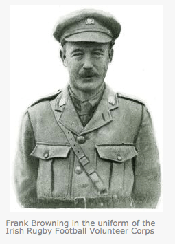
above: Frank Browning, was a former Irish cricket and rugby international, as part of the of the Georgius Rex (Gorgeous Wreaks) amateur regiment he was shot and killed in 1916.
- You will often see cards and flowers to the rebels side as well of course, as well as to the civilian victims. Several civilians were killed in cross fire in this area in 1916.
- On the far side of the canal bridge, the buildings on the right of the road, facing over the canal, are Clanwilliam Terrace. The old Clanwilliam Terrace (see photo) was destroyed by fighting in 1916. It was occupied by an outpost of seven volunteers, led by George Reynolds. Like Malone and Crace at number 25, this outpost also held the Sherwood Foresters at bay for hours before the British managed to set fire to the house and drive them out. Three of the seven, including Reynolds died in the shooting before the house was set fire and had to be abandoned. Their bodies were incinerated in the blaze and noting remained to be buried.

- Causalities? In total around a dozen Irish Volunteers were killed in the fighting around here, around half a dozen civilians, and an extraordinary amount of British troops. Exact British death toll are hard to estimate but over 200 combined killed and injured (British alone) is a useful round figure. This was by far the most costly theatre for the British anywhere in the city, at any time, during Easter week 1916. Nowhere else did they suffer causalities in any way comparable.
The reason for this of course of course was the lines of fire, straight down Northhumberland Road, and the cover offered by several buildings, most especially number 25 and by Clanwilliam house, allied to some excellent shooting from a few men within. The other reason was an absurd, grim determination by Gen-Brigadier Lowe who ordered the rebel positions should be taken in direct waves of assault. This resulted in his men being exposed to a fire from high, well dug-in and protected positions. A tactic necessary on the trenches of the western front perhaps, but completely unnecessary here (and in any case, not best suited to urban warfare). From a British point of view, their commanders and officers on the spot should have also used more personal initiative. That they did not had devastating effects for the ordinary men and junior officers of the Sherwood Foresters.
- Walk down Percy Place and then turn left onto Percy lane. Jim Crace escaped across this lane, after his extraordinary escape from number 25 Northumberland Road, after Malone’s death. He dived into then hid in the gardens behind the houses of Haddington Road for a few days, before being caught in a house to house, garden to garden search by British troops towards the end of the week.
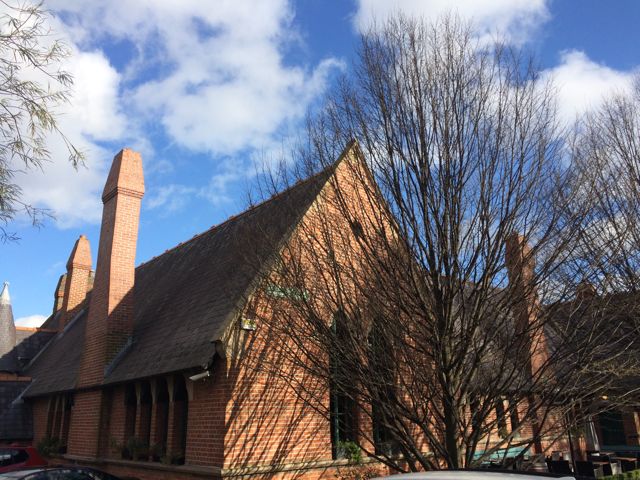
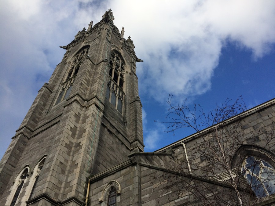
- Walk down Haddington Road to the final stoop of our walk, St Mary’s Church.
St Mary’s Church. One of the chaplains from the church was among the several civilian victims killed during Easter week. The British also commandeered the high Victorian spire here on top of the church as a firing point.
The church, interestingly has both a 1916 memorial plaque, and a WWI Memorial. In fact, for many years it was the only Catholic Church in Dublin with a substantial memorial to the Irish fatalities from the Allied side in the Great War. Both traditions respected, the church was well ahead of its time.
I hope you enjoyed the piece above and enkoy the tour if you get to walk it. The map should help you follow the route should you wish to copy and use it. (You’re more than welcome to grab the image, save, copy or print it off. It is copyright free and yours to use as you wish).
Anybody who’d like to have a guide on their walks, and see more public walks and routes as they come on-stream, please follow the blog. There is a “follow button” at the window on the top right of this page, and/or follow the very useful monthly newsletter, the quick subscribe is here. People who would like to book a private walk, on any of our routes, please see the note at the foot of the page. We also have gift vouchers available around Christmas each year, a nice present for the history buff in your life.

Credits: chief consultant on this project was writer and local historian Hugh Oram. Hugh has lectured on and written several books about the area. His encyclopedic knowledge of the secrets and lore of Ballsbridge was indispensable. I also received generous help from Gerald Whelan, head librarian at the Royal Dublin Society (RDS) In fact all of the RDS library staff were unstintingly kind and generous in their help.
Additional reading research was carried out at
- the Dublin City Library and archive at Pearce St;
- 2- the Library of the Royal Dublin Society (Merrion Rd);
- 3- the Library of the Royal Irish Academy (Dawson St) and
- 4- Pembroke Library on Anglesea Rd
- Online Resources: Bureau of Military History, Witness Statements. (Especially WS.310, from James Grace.
The following exhibitions were also very useful in helping me extend and develop my own understanding of the conflict in general, and of the Battle of Mount St Bridge in particular.
Citizens in Conflict: Dublin City Library and archive at Pearce St; (especially the voice recordings taken from diaries, letters, Witness statements etc)
A Republic Proclaimed: National Museum at Collins Barracks.
Surgeons and Insurgents: RCSI, St Stephens Green.
Pribably the best source of all about the Easter 1916 Rising is the amazing resource we have the Bureau of Military History’s Witness Statements, collected and recorded mostly in the 1940s, when of course many of the participants and witnesses were still alive. A few of the statement are handwritten, making some hard to decipher, others are typed, but all together they represent an incredible resource, the first person voices helping to suddenly bring the events very vividly to life. In the project above I especially made use of (Witness Statement) WS.310, from James Grace, who was in 25 Northhumberland Road with Michael Malone.
Thank you to all the individuals, exhibition organizers, curators, librarians and institutions who assisted me. I am of course, especially grateful to the Dublin City Council 1966 Commemoration Fund for the grant which allowed me develop the project and to deliver the walks for the public. My thanks in particular to Tara Doyle of the Dublin City Libraries for her help and encouragement.
This tour was designed by Arran Henderson. Arran runs tours under the banner “Dublin Decoded” for both open, public events and events for private groups. Bespoke, corporate and custom tours are available via an enquiry to dublindecoded@gmail.com We are a small firm, so if you are enquiring about a private tour, to ensure a speedy response please put your preferred dates up in the subject header. Many thanks in advance.

Very comprehensive post packed full of fascinating facts! I trust you have published a booklet with all of this excellent research.
LikeLiked by 1 person
You are very kind, the comments are much appreciated. I just wish I had the money or funding to publish a booklet!
LikeLiked by 1 person
Dublin city council? History press?
LikeLike
You’re right, I should talk to them both. Giving 4 tours over the next few days so its all a but frantic here at present. But I’ll speak to them both once the current madness calms down. 🙂
LikeLiked by 1 person