As you see on the below map by that Huguenot genius John Roque, Parnell (Rutland) Square in 1756 was hardly laid out with any buildings.
The famous Lying In Hospital (Rotunda) had been founded by Dr Bartholomew Moss was there (built by Richard Cassels) was there, and Cavendish Row/Street itself. and not much else.
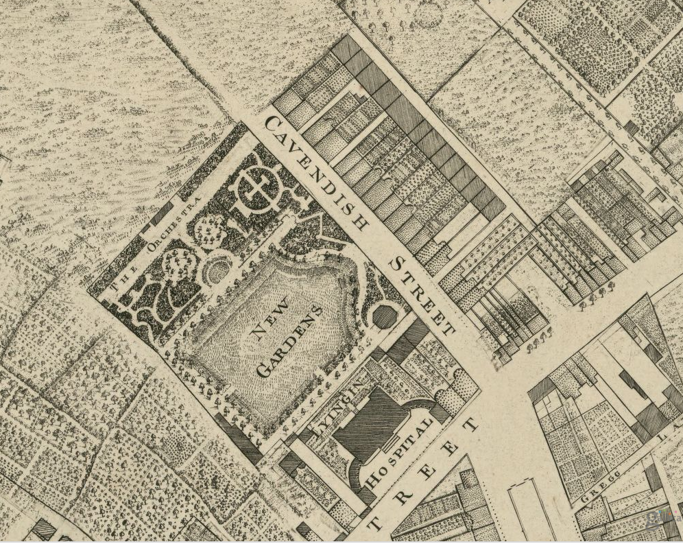
To the North especially, all was empty, fields and trees, farms and orchards. Charlemont House was yet to be built for James Caufield. So too were the new entertainment spaces, the ultra-fashionable spaces owned by and used for fundraising for the Rotunda. We today call the Ambassador and Gate Theatre buildings. Only the main hospital was there in 1756, its beautiful formal gardens, some sort of pavilion by the looks of it, and an area called the The Orchestra” where presumably the musicians used to play. No wonder Dublin was once called “the Naples of the North”

Immediately south of the Hospital, a very grand boulevard, Sackville Mall, the dream child of Luke Gardiner the elder is already laid out. But it only runs for about half the length of modern day O’Connell’s st. A much smaller street, Drogheda Street then ran the rest of the length, running southwards towards the Liffey, but even this didn’t connect properly with the Liffey, as you can see in this picture below.

Instead, at the bottom south end of Drogeda Street, a clutter of street junctions – South Lotts, and Great Abbey St, (which Roque has spelt “Abby”) and various plots, shops, dwellings and warehouses, all block access to the river.

Perhaps it doesn’t matter anyway, because modern-day O’Connells Bridge, or even Carlisle Bridge, (to give it its former name) also doesn’t exist yet.
Looking back up to the top left (NE) of this map, you’ll see Great Marlborough Street (only “Great M..” visible here). Tyrone House, (also Richard Cassels) isn’t built yet. Nor, obviously, is the Pro-Cathedral. But the vital, all-important Bowling Green is there!
Marlborough Street today has to be one of the filthiest, saddest run down streets in the North Inner city, (in the face of serious competition) It’s emblematic of the entire decline of the entire area, which neither the state nor the City government seem willing to do anything about. Affairs are now at crisis stage, and despite time wasting endless reports and conferences, there’s little real hope on the horizon. Until they are prepared to become radical and take the bull by the horns, finally confront private property rights, and introduce compulsory purchase orders, the neglect and destruction will continue and we will will loose precious buildings year by year. The old cinema, then old Wax Museum on just off Rutland/Parnell Square, o Granby Row, was ripped down in 2005. Underneath the hideous concrete facade, it was actually a building by Frederick Darley,
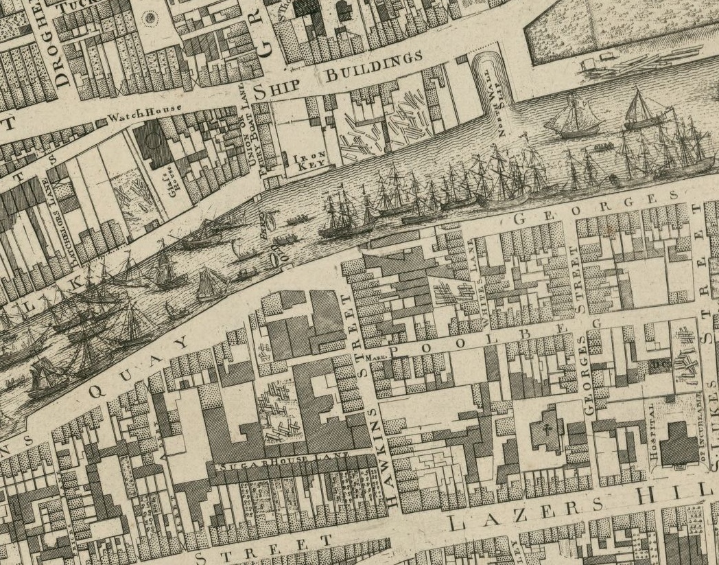
Looking at this map always pleases and fascinates me though. You have to admire Roque’s ships. They are beautiful. Look at the little Watch House too, on Ship Buildings (street) and between that lane and the river, look at the little lumber yards. These presumably are shipwrights yard for repair of those sailboats. The timbers there are located between “Iron Key” and the North Wall Slip.
That’s “key”, not “quay” interestingly, although quay is of course the word Roques uses elsewhere along the river. It is all most intriguing. I wonder what the Iron Key was? One is tempted to think Iron workers, making iron parts for the ships.
Going to the very bottom (S) of this frame, Lazars Hill is of course now Pearse St. It was clearly Lazars Hill before it was Brunswick Street, before it was changed again to Pearse St. In the old world of Templar and Hospitallers and early health care, and in medieval Christendom generally, the word Lazars and Lazarus (and St Stephen) generally referred to leprosy and its treatment. The ancient hospital in this area however, was once known as St James. But that’s not so surprising either, when you think of it. Back in medieval era, many of the people making their way down to quays and the river here would have been traveling on pilgrimage, many of them to Santiago de Compestella. To the shrine of St James. These pilgrims often got sick along the way, and religious orders would look after them. They also had their pilgrims passports stamped along the way. The Dublin stamp was collected, a mile or so to the west of here. At St James Gate.

Why Lazars ‘Hill’ Arran? It’s flat as a pancake isn’t it? Yes, Marlborough Street is pretty crummy but I used to enjoy a stroll up there towards Dorset Street and it’s clearly seen better times. It was clearly the main drag down to the river in those days.
LikeLike
Indeed it was. And clearly much grander, with Lord Tyrone siting his house there, etc. Now however its a very sad and shabby spectacle, grim, dirty and windblown. Breaks my heart.
LikeLiked by 1 person
Hi Arran. I am sorry you did not respond to my email inviting you to an event in UCD which I was sure would interest you. Perhaps you might like to tell me how you accessed Roque’s map in digital form? Your passion for Dublin’s architectural heritage is certainly refreshing
LikeLike
Emer, I did indeed respond, but I could only respond under your comment on my blog, since you did not provide an email address, nor details of the event, i noticed! :)) Send me your email address this time, and I’ll send you a link to Roque’s map, Best- Arran.
LikeLike